| Home - Back Issues - The Team - Contact Us |
 |
| Volume 11 |Issue 29| July 20, 2012 | |
|
|
Cover Story
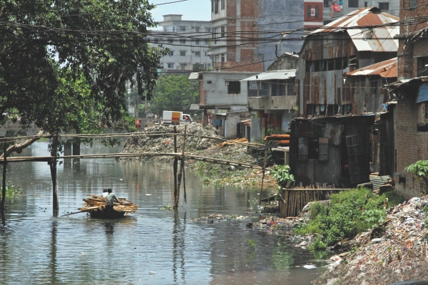
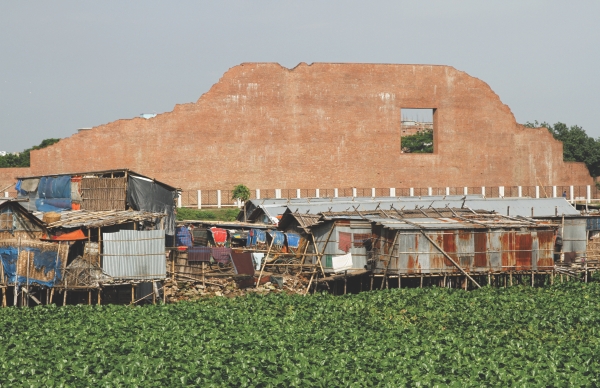
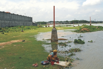
Choking the Lifelines In the last two decades, two things have happened: the Dhaka city has expanded and the rivers around it have shrunk. Huge shopping complexes, supermarkets, universities, hospitals, housing projects and even mosques occupy 40 percent of the areas that were once lowlands, the flood flow zones that used to remain submerged during monsoon every year. The ruthless arrogance with which we are killing the lifelines of the city have already had terrible consequences. What kind of a city are we leaving to our future generations? Akram Hosen mamun Since the independence of Bangladesh, Dhaka has expanded beyond imagination. It is, in fact, one of the fastest growing cities of the world. On the other hand, the rivers and wetlands around the city have at a shocking rate shrunk, and in some places, disappeared altogether, making way for supermarkets, housing projects, private universities, hospitals and even mosques. A 2010 study of the department of Urban and Regional Planning of Bangladesh University of Engineering and Technology (Buet) says that around 40 percent of the wetlands of Dhaka has disappeared in 20 years. Another survey conducted by a Buet teacher, on the city's wetland reckons that if the encroachment continues at the current pace, all wetlands will completely disappear by 2035. A walk on the street of Keraniganj along the banks of the once mighty River Buriganga reveals how much of the river has been encroached by commercial enterprises. Pillars have been set up for demarcating the perimeters of the river. But it appears as though the pillars were set up to give an air of legitimacy to the structures on the bank. However, there are no signs of demarcation in front of Alam Tower, a huge shopping complex beside the Zilla Parisahd Market. "The building has not encroached upon the river. The river has a bend in front of it. That's why this building looks as though it's been constructed a little further than the others in the area," says a staff of the owners' office. None of the owners of Alam Tower could be reached for their comments.
The district administration has apparently raised the boundary pillars along the banks of the Buriganga River in Keraniganj to save the foreshore. Asked why there are no pillars in front of Alam tower, Md Mohibul Haque, deputy commissioner of Dhaka, says that the task of setting up the pillars has not been finished yet. He also hopes to demolish the parts of any buildings that have encroached on the foreshore. But he can't make any specific comments until he sees how things turn out during the drive to demarcate the rivers with pillars. “During monsoon, the rivers seem much wider than they actually are" he claims. "We set up the pillars in winter, and if you want to know what it was like then, we can show you pictures of the river in winter.” Interestingly, the officials of Bangladesh Inland Water Transport Authority (BIWTA) follow the same line of thought. On conditions of anonymity, a high official of BIWTA advised this correspondent to visit the rivers in winter to see if the demarcation boundaries have saved the foreshores. "During monsoon, the river floods its banks and then the structures set up nearby appear as if they were occupying the river bed," he says. The unsavoury truth is that the authorities responsible for protecting the rivers seem to be oblivious of the importance of preserving the flood flow zones and maintaining the integrity of the natural course of the rivers. In their natural course, our rivers spread in width during monsoon, flooding a vast area along the banks. Despite the fact that it is July, and monsoon season, the Buriganga River is no more than a monstrously swollen drain. The stench of toxic wastes and filth rises from the thick dark water and hangs over the river. To protect the city from monsoon flooding, the Buckland embankment on the northern bank of the Buriganga River along the southern front of the city was constructed in 1864.
Architect Iqbal Habib, member secretary of Bangladesh Poribesh Andolon, informs that when the planners expanded the embankment, they reckoned that a vast area on the opposite side of the river would be flooded during the monsoon. In fact, they defined the area as a flood flow zone. "But now, the housing projects of Basundhara Riverview and Rajuk have begun to fill the opposite side of the river as well, and Keraniganj has become a part of the city," says Habib. With the embankment on one side and wholesale filling up of the bank on the other, the water in the much narrowed river can't go anywhere during monsoon. As a result, the level of the water rises during heavy downpour and flash floods occur in the city. Beside the Zilla Parishad market in Keraniganj, a canal, goes inland. Large buildings flank the canal, the width of which has been reduced significantly over the years. There are many textile dyeing factories in the area. All of them leave adulterated, dark blue dye residue through pipes in the canal. No species of fish can survive in this level of toxicity. As the sludgy river water drifts and ferries all the garbage we discharge in it to the sea, the toxicity spreads. "People can feel the toxicity in river water from as far downstream as Chandpur, Matlab, and Gazaria," says Engineer M Inamul Haque, chairman, institute of water and environment. He estimates that we are losing fish worth more than Tk 30,000 cr every year. "Even if we stop polluting today, it will take several decades for the fish to return and breed here again," he says. Explaining another consequence of filling up the river banks, Iqbal Habib says that after heavy downpour the water cannot immediately flow to the river because the water level of the river rises during monsoon. Consequently, after each heavy shower, the sewerage pipes and storm drains overflow and the filth comes up on the street. When the street water recedes, the filth dries out, pollutes the air and spreads diseases. The Department of Environment (DoE) has the responsibility to secure a clean and healthy environment for the benefit of present and future generations. But the Director, Enforcement of DoE, Muhammad Munir Chowdhury says, “The manpower in his department is very much insufficient to combat the polluters and encroachers.” Rajuk also has a major role to play in rescuing our rivers from encroachers. But the high officials of Rajuk are not happy with their manpower either. Sk Abdul Mannan, a member (planning) at Rajuk expresses hopes that “in the next six months we will get new recruitment in the organisation, and we hope that things will be different then.”
Environmentalists, however, insist that the lack of manpower in the government authorities is not a serious problem at all. By creating widespread awareness about the importance of rivers and by empowering the general public who will not sit back and watch while big corporations and businesses set up manufacturing plants and supermarkets on the rivers, Rajuk and DoE's lack of manpower could be compensated. “It's ridiculous that they keep complaining about manpower in a country that has a population of 16 crore,” says Syeda Rizwana Hasan, Chief Executive of Bangladesh Environmental Lawyers Association (Bela). "We have been asking the authorities to set the demarcation lines properly and inspire the local people, an overwhelming majority of whom want to save the rivers," she adds. In another part of Dhaka, the Shaheed Intellectuals Bridge (the third Buriganga Bridge) connects Mohammadpur with Keraniganj. Only a couple of years have lapsed since the opening of the bridge. But the landscape of the entire area has undergone dramatic changes. Both sides of the road from Mohammadpur bus-stand to the bridge has been filled up with soil and sand. In fact, it is hard to believe that the whole area was actually part of lowland that used to get submerged for about six months every year. The bridge offers a view of the Buriganga River from an elevated place. The banks are crammed with multistory buildings constructed in a haphazard manner - the story of all the rivers of this city. A large patch of land behind the Rayerbazar Mausoleum is also being filled up. Several buildings and mosques are under construction. Abdur Rahman Khan, a middle-aged man who has been living in the area for many years, has a piece of land in the canal. He has already filled it up but hasn't started any construction yet. "Nobody said anything when I filled the lowland. In fact, everybody who owns a piece of land here is doing what I have done," he says. A large billboard of Sentry Security Services Limited can be seen from the embankment. Inside its boundary, the lowland has been filled up by sand and soil. The compound has an orphanage at the back. Md Hasanul Islam, Managing Director of the company informs that there is a writ petition at the high court for their land. “I don't think filling these lowlands with soil is illegal because the whole area along the embankment has been filled in front of everyone,” he says. He also adds that the wetland is 1500 feet away from the compound. Not surprisingly, the people who grew up in the area beg to differ. They assert that the entire area along the embankment used to get submerged under water during monsoon. Asked for his comments, Sk. Abdul Mannan of Rajuk says, “The encroachment has been going on for years. We can't solve the problem overnight. We are planning to proceed gradually.” He also adds that BIWTA and other agencies are also taking actions against illegal structures that have been constructed upon the rivers. At some 20 km North of Dhaka city, Biswa Ijtema ground is located on the banks of the Turag River. Across the river, there are large buildings belonging to the International University of Business Agriculture and Technology (IUBAT), a multistory complex of Ahsania Mission Cancer Hospital is under construction, and a large piece of land has been filled with soil by the American University Bangladesh. The foreshore of the Turag River has been encroached upon for miles at a stretch in the area. Demarcation pillars have been set up by the district administration on both sides of the river. But the pillars have allocated a thin line for the river. It does not require specialised knowledge to understand that very little space has been reserved as foreshore, let alone a flood flow zone. A few kilometres to the north along the embankment, at Mouza Vadam in Tongi, Gazipur, a campus of East West University has its boundary walls constructed near the river bank. Most of the space within the boundary is still under water. In order to make the lowland a usable campus, more filling will be required no doubt. Colonel Shah Murtoza Ali (Retd), registrar of the university informs that the land was bought from private owners. He also states the obvious: "Our boundary walls do not cross the demarcation lines set up by the administration." It is also obvious that after a few years, the Turag River will not have any flood flow zone near the city during monsoon. Its fate will be the same as that of the Buriganga River near Keraniganj excepting that it will become much thinner by the 'legitimate' encroachment of housing projects, universities and other miscellaneous structures.
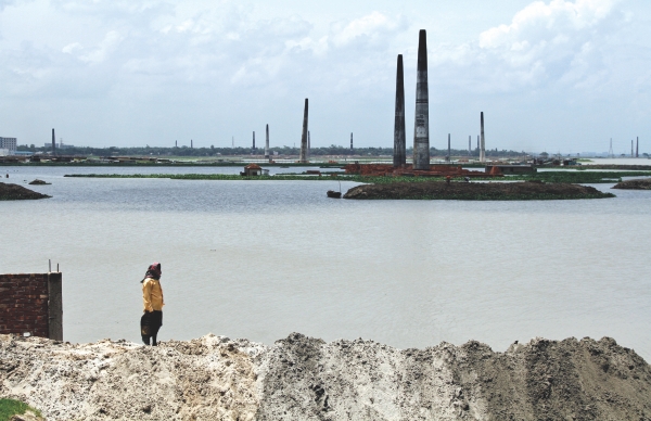
Dr M A Matin, General Secretary, Bangladesh Poribesh Andolon says that 400-500 feet of the Turag River is being encroached upon by some private universities and hospitals. The consequence of this practice is the eventual death the river. The city will become unlivable without the rivers. The district commissioner of Gazipur was not available to talk about the demarcation pillars in the area. However, Bangladesh Inland Water Transport Authority (BIWTA) that assisted the district administration in setting up the pillars had initially objected to the demarcation line, informs a BIWTA official, on conditions of anonymity. He says that the representatives of BIWTA objected that the pillars that were set up from Tongi Ijtima ground to Ashulia Bridge and did not leave enough space for the river. "After a lot of hubbub and a visit by the state minister of land, the pillars were relocated, increasing the border of the river," he says. Even after relocation, it is clear that no space has been reserved for the flood flow zones and it ultimately allows enterprises to fill up the low lands with apparent legitimacy. Looking at the horizon from the Ashulia-Mirpur diversion road, all that is seen are formidable-looking, monumental chimneys emitting dark clouds of smoke over a vast expanse of wetland. The number of brick kilns on the lowland is immeasurable in the area. According to a World Bank report, in the North Dhaka cluster, brick kilns account for nearly 40 percent of total emissions during their 5-month operating period every year, making Dhaka one of the most polluted cities of the world. They are also the city's main source of fine particulate pollution. "But the law regarding the legitimacy of the brick kilns is unclear," says Rizwana Hasan. She adds that it is not illegal to establish brick kilns on the flood flow zones that do not have any residential area in a 150 feet radius. "But what is wrong with these brick kilns is that they use the traditional chimneys, not the zigzag or Hybrid Hoffman Kilns (HHF) or a similar technology that are energy efficient and reduce the emissions," adds Rizwana. Since the traditional, outdated kilns consume a lot of energy, they are a threat to our forestland as well. According to a study by Asit Ranjan Paul, divisional forest officer of Tangail, the unregulated brick kilns burn fuel-woods equivalent to 2.4 crore standing trees every year. Raihan Bin Shafiq, an NGO official who has been travelling extensively to Savar and Ashulia for the last seven years has witnessed a dramatic change in the landscape of the area. "I support industrialisation and development. But I don't understand why Mother Nature should have to pay the price. What will our future generations think about us?" he says. He also reminisces that the area was very popular for its clean air and scenic beauty. But the encroachment on the foreshores along the embankment and the brick kilns on the other side of the river occupying the lowlands are killing the environment. "Our problem is that we don't count the environmental or social cost of these industries," says Engineer M Inamul Haque. When factors like energy efficiency and emissions are considered, the eco-friendly technologies are far more cost-effective than the traditional ones. But the consequences on the environment are never considered while setting up the industries.
With its mobile courts, Rajuk has already taken several steps toward improving the situation in that area. It further plans to conduct another drive to demolish the parts of buildings that exceed the demarcation line this week, says Sk Abdul Mannan, Member (planning), Rajuk. Therefore, the filling up of lowlands and the structures that are being built outside the demarcation line will remain unharmed. While Rajuk, DoE, district administration and BIWTA lack coordination among each other and complain of scarcity of manpower, the lifelines of the city are rapidly becoming thin ribbons of toxic water. “The utter resignation with which the government departments are witnessing the destruction of the rivers is shameless,” says Syeda Rizwana Hasan of Bela. “The demarcation lines of the rivers are clearly designed to protect the illegal encroachers. They neither have any intention to protect the river, nor any hope to punish the encroachers,” she asserts. The groundwater level of the capital is depleting by two to three metres per year due to excessive extraction of groundwater. Taking that into account, the environmentalists believe that polluting and choking the rivers reflects nothing but a suicidal tendency. Environmentalists agree that the several government organisations that have the responsibility to protect our rivers, need to make coordinated and impartial efforts to save ourselves and our future generations from an imminent catastrophe: a barren and unlivable Dhaka. Encouraging the general public to take bold actions against the encroachers and providing them with legal support can also be an effective step. There is no other way to save our rivers. If we don't bring about radical changes now, our future generations will bear the brunt of the ruthless arrogance, with which we have been destroying Mother Nature.
|
||||||||||||
Copyright
(R) thedailystar.net 2012 |
|||||||||||||


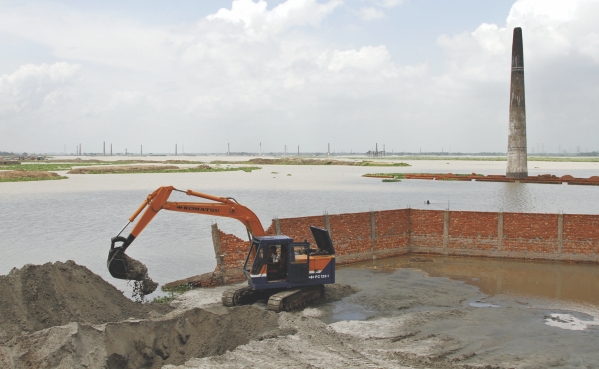
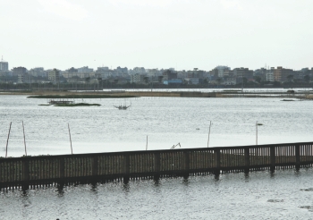 The BIWTA official, on conditions of anonymity, informs that the anomalies in deciding the area of the river have been going on for years. "Otherwise, people would not have been able to own lands on the banks of rivers," he says. The problem with people owning lands on river banks is that the administration can't intervene on private property like the way it can on government land.