Natural disaster

Cyclone may hit Bangladesh coast at 93kmph on Oct 25: IMD
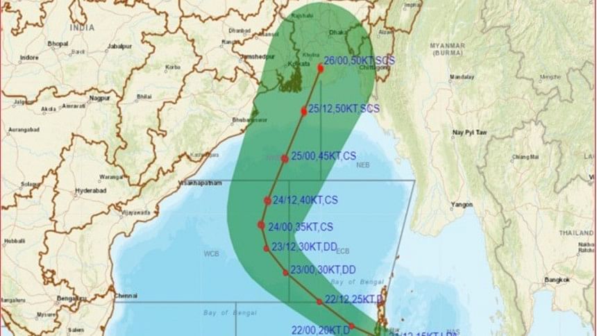
Cyclone may hit Bangladesh coast

The Indian meteorological department (IMD) provided a forecast an hour ago saying that a potential cyclone-storm is likely to hit some parts of West Bengal and Bangladesh coasts with around 93 kmph wind speed on October 25.

The IMD published track images of the cyclone storm saying that the low pressure (that persisted over the Southeast Bay of Bengal) will intensify further into a deep-depression on 23rd October and then is likely to recurve gradually northwards and intensify into a cyclone storm over west central and adjoining east central Bay of Bengal on 24th October.

On 25th October, the cyclone is likely to move to northeast wards and will hit near West Bengal-Bangladesh coastal areas, said IMD today at noon.

The Bangladesh meteorological department meanwhile forecast that the low-pressure is likely to intensify and the weather may deteriorate in the next 72 hours.

"Today (21.10.22), around 12.00pm, Japan's Himawari satellite imagery indicated that the low-pressure system in the south-eastern side of the Andaman Islands strengthened in the last 24 hours and turned into depression. At 12 pm today (Friday), the center of the depression was located at 12 degrees north and 95.5 degrees east. The maximum sustained surface wind speed was approximately 30 to 40 kmph," said Mostafa Kamal Palash, a weather and climate researcher at the University of Saskatchewan in Canada.
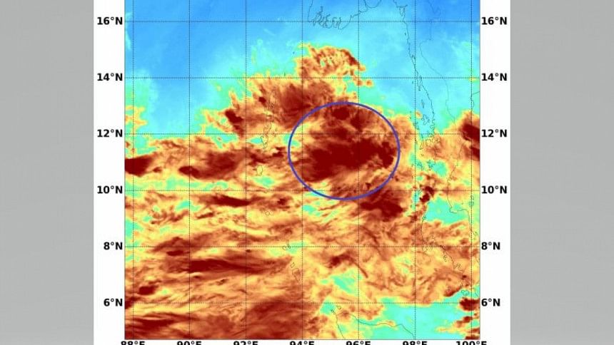
Water vapor imagery (indicates cloud top temperature, an indirect measure of cloud top height) taken over the depression located south-east side of Andaman Islands (approximately 250 km away from Port Blair) by Japan's Himawari satellite at 12:00 pm on Friday, October 21, 2022.

"The latest forecast of all major numerical weather prediction models indicate that the chance is very high that the potential cyclone "Strang" in the Bay of Bengal may make landfall over the coastal areas of Khulna and Barishal division from the evening of October 24 to the afternoon of October 25. During landfall, the wind speed will likely range from 110 km to 120 km per hour. With wind gusts up to 140 km/hour," added Mostafa Kamal Palash.

"The rain will start from October 23 and persist until October 26. The sea will be highly rough from October 23. All fishermen should return to shore no later than the morning of October 23," he suggested.


Comments

চুরি যাওয়া সম্পদ ফেরত পেতে বিশ্বনেতাদের সহায়তা চাইলেন প্রধান উপদেষ্টা

সুইজারল্যান্ডকে বাংলাদেশের যুবসমাজের সম্ভাবনা কাজে লাগাতে বাংলাদেশে বিনিয়োগের আহ্বান জানান প্রধান উপদেষ্টা।

৪০ মিনিট আগে