Deep sea port in Sonadia: A unique opportunity for Bangladesh
The development of deep sea ports as an economic infrastructure assumes that like roads, communications and other economic infrastructures, ports have a positive impact on the growth and development of countries. The economic history of maritime powers such as Britain, Spain and Portugal clearly documents the significant and critical role which ports have played in the development of their economies.
 Deep sea port development has positive effects on employment and revenue earnings of a country. The positive trade and balance of payments effects of good seaports and harbours cannot be denied. The cluster of activities in sea ports all over the world clearly show that ports have significant economic impact both locally,
regionally and nationally.
In fact, the leading sector of a country like Singapore is its deep sea port. Ports have enabled Japan to build export processing zones that have turned Japan into exporters of goods which cannot be produced on the basis of country's factor endowment profile. Theoretically, sea ports are an economic infrastructure with significant multiplier effects on the domestic economy. For Bangladesh there are at least four significant reasons for establishing a deep sea port in Sonadia, such as:
* to facilitate uninterrupted coal supply for the power plants to be established in Moheshkhali;
* to support the country's growing seaborne trade needs of the future;
* to go along with the global shipping trend of moving towards larger tonnage; and
* to utilise our geographical advantage to become a regional access door to the sea.
 Coal supply for the power plants to be established
The present initiative by the country's power sector to add 5320MW of electrical power to the national grid by 2020 from coal-based power plants to be established in Moheshkhali, will require about 23 million tonnes of coal annually, which is equal to the total annual output of Chittagong port in 2008-9. The daily requirement of coal will be over 60,000 tonnes and should obviously be imported by 'Handymax' or 'Supramax'-sized vessels drawing 12-15 metres draft. Neither Chittagong nor Mongla has the capability and/or connectivity to feed the future power plants by handling such vessels. For handling such vessels the establishment of a deep sea port in Sonadia is indispensable.
Growing seaborne trade
The total annual output of Chittagong port was over 45 million tonnes in 2011, which is more than 97 percent of country's sea-borne trade, growing on average at 9.2 percent per annum. Also the trend towards containerisation persists and container traffic is growing on average at 11.2 percent per annum. This trend is anticipated to continue or even accelerate in the foreseeable future, which indicates in 2020 the country's total annual seaborne trade will be in the region of 70 to 80 million tonnes. The figure is certainly beyond the capacity of Chittagong port which handles most of the country's seaborne trade. Though, with the increase of trade volume, some cargo will be forced towards Mongla in spite of a number of important constraints persisting therein. However, to allow an uninterrupted growth of the seaborne trade, establishment of a deeper sea port is the only option ahead.
Further, taking into account the existing port capacity and the growth of trade volume, a new deep sea port will have to be operational by the end of present decade (2020) even if Mongla and Chittagong ports are further developed. The possible expansion of the two ports however will have no dramatic impact on the forecasted trade volumes and there will be sufficient seaborne trade warranting a new deep sea port.
Economies of scale
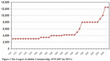
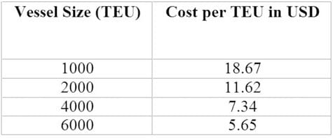
The principle of economies of scale is fundamental to the economics of maritime transportation as the larger the ship, the lower the cost per unit transported. This trend has particularly been apparent in bulk and containerised shipping. For instance, the evolution of containerisation, as indicated by the size of the largest available containership, has been a stepwise process. Changes are rather sudden and often correspond to the introduction of a new class of containership. Since the 1990s, two substantial steps took place. The first step involved a jump from 4,000 to 8,000 TEUs, the second step took place in the 2000s to reach the 13,000-14,000 TEU level. From a maritime shipper's perspective, using larger containerships is a straightforward process as it conveys economies of scale and thus lowers costs per TEU carried. See the table above for the comparative rate per container (TEU) transportation cost against the ship size on which they are carried.
 Thus, the matter of scale is bringing forward a paradox as the more economies of scale are applied to maritime shipping, the lower the number of ports able to handle such ships.
See the above figure for how the ship size in container trade increased over the last four decades.
 Chittagong port has significant limitation on the length and the draft of vessels entering the port. The main constraint to vessel length is imposed by the Gupta bend in the Karnaphuli river, which has a natural minimum radius of about 1,000m. The corresponding estimated maximum vessel length would be approximately 190m. Further in the navigation channel of this river, there are three submerged sand bars, namely Outer Bar, Inner Bar and Gupta Bar, which allow vessels of a maximum draft of 9.2m to enter the port. Vessels of such dimension cannot carry more than 1,500 TEUs.
Mongla port is situated about 69 nautical miles from the Pussur river mouth. The maximum permissible draft of the vessels that can enter the port jetties varies between 7.0m and 8.5m depending on the tide and weather conditions and there is a length restriction of up to 225m. This port also cannot handle larger container vessels.
Bulk cargo vessels also face similar problems in our existing ports. Since the existing two sea ports are situated along the bank of the rivers with draft limitations in berths, none of the ports can accept large vessels at berth. Lighterage is required for a substantial portion of the import trade from anchorage in the bay that causes higher freight rates and low productivity of our sea borne trade. To improve these situations and go along with the global trend, establishment of a deep sea port for handling vessels with deeper draft and longer length is the solution.
 Geographical advantage
Bangladesh stands on the vortex of the Bay of Bengal, blocking the sea access to the entire region laying north, north-east and north-west of her, which includes seven north-eastern states of India, Kunming city in China, and Chin and Rakhine states in Myanmar. A narrow deep strip of the Bay with a natural depth of 14m has protruded close to the Sonadia Island, south-east of Bangladesh. This is the deepest point of the Bay to approach the land.
The bathymetric (sea bottom topography) condition of the area has been stable for more than 100 years and is hydraulically balanced. The area may be considered a gift of nature for Bangladesh. Utilising this rare opportunity, Bangladesh should develop a port in the area for deep draft larger vessels, primarily to improve our present condition and fulfill our own needs, and additionally to allow others to have access to the sea, which may unveil a new horizon for developing the country.
Importance for development
World civilisation started developing on the seashore or waterfront first and then gradually moved inwards, with links to the sea. Lack of direct access from sea can severely slowdown the development of a region. Seven north-eastern states of India could be sited as an example nearest to us. So for obvious reasons India is desperate to connect these landlocked states with the sea. India attempted negotiating with Bangladesh since the 1970s for transit access from the Bay of Bengal to these states, but was repeatedly denied by the latter.
India's alternate strategy
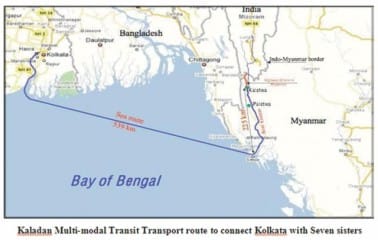
In April 2008 the Indian government signed an agreement with Myanmar for the Kaladan Multi-Modal Transit Transport Project. The project will connect the landlocked area of Northeast India with the sea via Western Myanmar and open up trade routes to South-east Asia (see map).
The Kaladan Multi-modal Transit Transport Project was conceived, primarily to provide an alternative route to seven north-eastern states of India. Presently the only access to these seven states is through the Siliguri Corridor, a narrow strip of Indian territory wedged between China and Bangladesh. Routing all cargo destined for the northeast states through this corridor causes significant transportation delays and cost overheads.
The Kaladan project was hence aimed at accelerating infrastructure and economic development in the land-locked north-eastern states. The project will connect Kolkata sea port in East India with the sea port in Rakhine capital, Sittwe – a total distance of 539 km. It will then link Sittwe to the landlocked area of Mizoram in north-eastern India via river and road transport.
According to the framework agreement, the government of the Union of Myanmar will provide the required land and security for all Indian workers for free. The Indian government will pay US$110 million and a loan of further US$10 million to the government of Myanmar to cover the remaining expenses.
On completion, the project will be handed over the government of Myanmar on terms and conditions mutually agreed upon. It is clear, however, that the transport system will be primarily used by Indian companies to increase trade with Southeast Asia and to link the landlocked area of Northeast India to the sea.
Deep sea port development in Myanmar
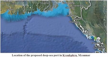
Myanmar has decided to build a deep sea port in Kyaukphyu, western coastal Rakhine state, to facilitate transit trade through the country (see map).
The Kyaukphyu sea port will serve as a transit trade centre. As part of the country's infrastructural construction, the Kyaukphyu deep sea port will be built with offshore and deep-sea fishing industry to be established in addition to sea lobster farming.
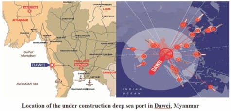
The governments of Myanmar and Thailand have signed a Memorandum of Understanding (MOU) in May 2008 to develop another deep sea port in Dawei and a connecting road link to Bangkok (see map).
The project includes the development of a deep sea port, an industrial estate divided into six industrial zones including a residential/commercial zone with related infrastructure within the industrial estate, a connecting road and rail link to Thailand as well as oil and gas pipeline from the Gulf of Martaban to the Myanmar/Thailand border along the road and rail link.
Deep sea port development in India
There are twelve major sea ports in India, including Kolkata/Haldia, Paradip, Visakhapatnam, and Chennai on the east coast. In terms of total cargo handling volume, Visakhapatnam is the largest port, followed by Kolkata/Haldia. In 2005, Kolkata/Haldia port handled approximately 46 million tonnes, including 290,000 TEUs. Fifty percent of the containers handled in Kolkata is related to Indian trade, and about 40 percent is related to Nepal and about 10 percent to Bhutan.
Both Kolkata and Haldia ports suffer from chronic siltation of the Hugli River. To resolve this problem, India has a plan to develop a deep sea port in another location, to handle large-sized vessels. The area of Sagar Island, which is located 145 kilometres south from Kolkata city, is proposed for establishing a deep sea port for container vessels. Another plan for a container port is Diamond Harbour, which is located at the eastern bank of Hooghly River between Kolkata and Haldia. The feasibility study is under way by Indian authorities.
Impacts of regional port developments to the proposed deep sea port in Bangladesh
When the planned and proposed port developments in Hooghly River are implemented, transshipment cargoes only from Nepal and Bhutan will be handled through these ports. This port cannot be used as a hub port for serving the landlocked states of India, China and Myanmar. The small amount of transshipment cargo to and from Nepal were handled at Bangladesh's ports more than a decade ago, however, in recent years no transit cargoes to and from Nepal have been handled at Bangladesh's ports. Therefore, it may be concluded that the impact of port development in India is very limited on the future port developments in Bangladesh.
The Kaladan Multi-modal Transit Transport Project will link seven north-eastern states of India with Kolkata and Myanmar. The Sittwe port presently can handle vessels of up to 2,000-3,000 tonnes of deadweight tonnage (dwt). Under the project this port will be further developed to handle vessels up to 4,000-6,000 tonnes dwt which are considered as coastal vessels with very limited capability and cannot be deployed in worldwide international trade. International trade of the seven landlocked states will still have to be carried out through Kolkata port by traversing over 800 extra kilometres (539km sea + 225km river + 62km road) of extra distance. The distance from landlocked states of India to the deep sea port in Sonadia, Bangladesh, when established will be less than one quarter of the distance to Kolkata and will always remain as the first economic option for their international trade.
The idea of the deep sea port in Kyaukphyu, western coastal Rakhine state of Myanmar is yet to be conceived fully. The location is about 100 km south of Sittwe and the site will have limitations of draft compared to Sonadia. However, because of its distance from the seven sisters, Sonadia will always have an advantage to become a regional hub port. A deep sea port in Kyaukphyu may serve as an alternative port to overcome the limitations of the Yangon port of Myanmar but can hardly affect the geographical advantage of Sonadia.
The Dawei deep sea port of Myanmar will serve Thailand by connecting Bangkok with Andaman Sea through road and rail link across Myanmar and will have no impact on Bangladesh whatsoever.
In view of the above mentioned ongoing initiatives and activities it may be concluded that the present and proposed port developments in the region will not have much significant effect on the proposed deep sea port in Bangladesh.
A unique opportunity for Bangladesh
None of the deep sea port sites in the Bay of Bengal other than Sonadia has the potential to serve the broader hinterland region lying behind. The geographic position of Bangladesh could offer real opportunities to play a major role in regional seaborne trade and act as a gateway for this region to the rest of the world by providing shortest land connectivity route to the deepest water, saving thousands of kilometres transport costs and time.
At present, every parcel of cargo from Kunming in China has to travel about 1,800 km on land to the east to reach the nearest sea port in the China Sea from where it is transported by ships bound for the markets in Europe, traversing a sea distance of 18,300 km. In future, the same parcel may reach Sonadia, when established, travelling only 1,000 km to the west and then may be transported to Europe traversing a sea distance of 15,100 km with a total net savings of 4,000 km. Same applies to every parcel to and from the seven north-eastern states of India.
The volume of traffic and revenue earnings of the deep sea port once established, with all connectivity and political understanding with the neighbours, will have a direct link with development activities of the seven-sisters and China. Without going into details, it may be reasonable to expect that with a functional deep sea port in Sonadia, our GDP will be raised to a higher single digit figure, if not double digits.
Having such a unique advantage in our possession it is for
us to decide how quick we shall move to take home the benefits of this natural resource or opportunity.
In response to our government's recent invitation to build the deep sea port with external cooperation, quite a few countries and organisations, including China have promptly expressed their interest to involve with the development of the Sonadia deep sea port. Besides China, Japan, India, United Arab Emirates and the US have also shown interest in building the port. Our reaction to their interest is rather slow, the government is in a quandary over who to pick as its relations with all five are strategically and economically vital. Realising the Bangladesh government's dilemma, China has even offered to remain open to building the deep sea port in partnership with other countries.
A decision to build the port should be taken without any further delay. There is no doubt about the potentiality and the opportunity that exist. The two ever rival political parties of the country that could not reach any consensus on any national issue have surprisingly had a consensus on this particular issue of a deep sea port. Both parties included the same point in their last election manifesto. Furthermore, the Nobel laureate Dr Muhammad Yunus has also emphasised on the establishment of the deep sea port in Sonadia. This country is a natural disaster-prone country with limited natural resources to support an enormous population. The Sonadia site, with suitable parameters to establish a deep sea port, is a rare opportunity to ensure a better living for the people of this land from its own resource. We must act sensibly with vision and honesty.
The writer is a Master Mariner (U.K.) and former Director General, Department of Shipping.

 For all latest news, follow The Daily Star's Google News channel.


Comments