Environment

Early flash floods in the haor region: A new normal?
Early flash floods in the haor region:  A new normal?
PHOTO: COLLECTED

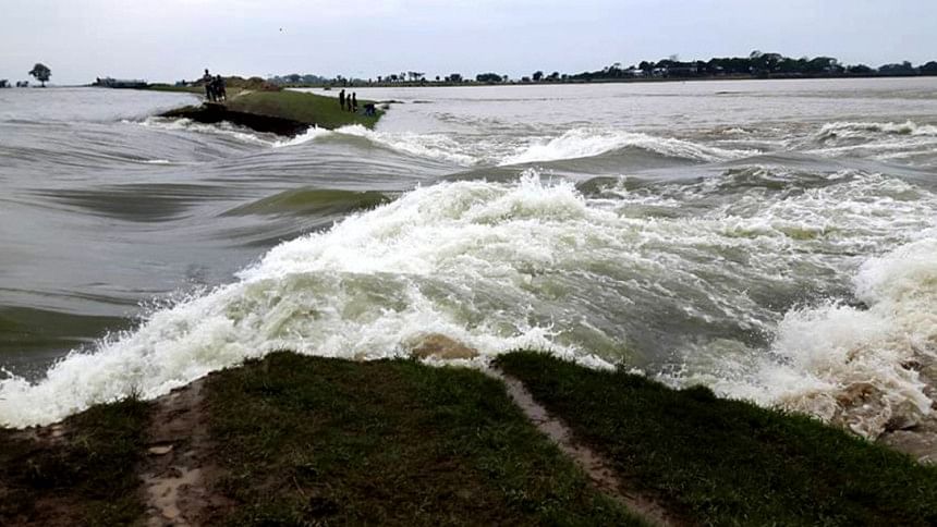
A flash flood in early April of 2017 devastated the boro crops in six haor districts that were worth Tk 13,000 crore (Kaler Kantha, July 8, 2017). Since then, a shadow of anguish engulfs millions of farmers every time there is a grey cloud in the northern sky in early April. This year too, according to news reports, rain accompanied by hailstorm damaged crops on vast tracts of paddy fields in Kishoreganj and Moulvibazar districts during the first week of April. 

In general, yearly floods in the haor region occur during late April and last for several months. Boro crop is harvested after Bangla New Year around April 15 or so. Any early hailstorm and flash flood during late March or early April cause havoc for farmers. In addition to damaging the boro crop, the flood in 2017 also devastated poultry, fisheries, and livestock in Netrokona, Sunamganj, Sylhet, Moulvibazar, Habiganj, and Kishoreganj districts (The Daily Star, April 17, 2017). Flash floods in the latter part of March or early April are not a regular occurrence in the haor region as it happened in 2017 and 2019.

Against this backdrop, it is imperative to investigate the underlying causes of early flash floods in the haor region and to look for possible solutions to such devastations. Are the early floods becoming a new trend in our weather?

First, let us investigate underlying causes of any flood in a region and the reasons why the frequency, magnitude, and duration of floods increase over time. The causes of floods can be broadly divided into several categories: (1) the amount, timing, and duration of rainfall over a catchment or watershed area, (2) an increase in surface run-off following a rain event and a decrease in water-carrying capacity of natural drainage network within the watershed to accommodate the surface run-off, and (3) a reduction in land elevations in floodplain in comparison to riverbed and sea level.

Most rivers in the haor region originate in Meghalaya and Assam states in India. About 60 percent of the total catchment area of the rivers draining the haor region are located outside the territory in Bangladesh. Part of the rainfall in upper reaches of the watersheds ends up in rivers, creeks, and beels in haors as surface run-off. It should be mentioned that Cherrapunji in Meghalaya receives the highest amount of rainfall in the world, which eventually drains through the haor region. A total of 1,262mm of rain fell at Cherrapunji during the period between March 28 and April 4 in 2017, which was 5.5 times greater than the amount of rainfall during the same period in 2016.

Besides, the rainfall occurred in a consecutive manner, which did not allow enough time for the downstream rivers in the haor region to effectively discharge the surface flow to the ultimate destination—the Bay of Bengal—through the Meghna River at Bhairab Bazar. To calculate the total amount of surface flow in rivers that results from rainfall in various parts of the watershed, it is important to have hourly and daily rainfall data for various locations within a watershed.

Although continuous rainfall data at a rain gauge station at Cherrapunji is available on the Internet, such data is not publicly available for other locations in the haor region. However, monthly average rainfall data starting from 1901 for Garo, Khasia, Jaintia Hills, and Sunamganj is available, except for Sunamganj, for which data since 1956 is available. A statistical analysis of the monthly rainfall data reveals correlations between the rainfall in Cherrapunji and all the other locations. Based on such correlations, the amount of daily rainfall was calculated for Garo, Khasia, Jaintia Hills and Sunamganj for the period of March 28-April 4 in 2017. For example, although the amount of rainfall at Cherrapunji was 1,262mm during the duration of the flood in 2017, Sunamganj received only 350 mm during the same period.

An analysis of average monthly rainfall data also revealed that during 1901-1957, the total amount of rainfall in May was much higher than in April and that there was a 3-5-year periodicity in the amount of high rainfall in May. However, the data indicated that during 1958-2017, the gap between the monthly rainfall in May and April has declined and that the amount of rainfall in April has increased. This is worrisome, because more rainfall in early April will mean increased incidents of flash floods in the haor region, which will cause havoc on boro crop in the future. Hopefully, this year's early rainfall accompanied by hailstorm is not a sign of validation of the changing patterns in rainfall in the haor region. If the occurrences of early flash flood become a new normal, then a lot more research will have to be done to adjust the crop type and embankments in the haor region to protect the crop.

Now, let us investigate the water-carrying capacity of the rivers in the haor region. An analysis of satellite images of the region indicates that most of the rivers have lost depth and width over the last few decades, resulting in a net loss of water-carrying capacity during floods. The reduction in water-carrying capacity has resulted due to siltation in riverbeds, land-use changes, unplanned development, deforestation within the watershed, and unplanned mining of sand from riverbeds. In addition, building of roads and embankments also interferes with the natural flow of surface water in the haor region.

For instance, the width of the Jadukata River near the India-Bangladesh border was 168m in 2004; it stood at 68m in 2017. The total cross-sectional area of any river increases as it flows downstream to accommodate more flow from groundwater and tributaries. The analysis of the changes of Ghorautra-Meghna River indicates that its cross-sectional area, which is indicative of its water-carrying capacity, has drastically declined at Bhairab Bazar bridge. It should be noted that all surface water flow in the haor region discharges through the Meghna River at Bhairab Bazar. This reduction in water-carrying capacity at Bhairab Bazar can be attributed to slow discharge of upstream flow which, in turn, is responsible for prolonging the haor floods.

The increase in sea level due to climate change is compounding the flood problem further by making all inland river sluggish due to backwater effect, and by reducing surface elevations of floodplain with respect to sea level and riverbeds.

What are some possible solutions? I think we should increase the water-carrying capacity of the drainage network in the entire watershed; supplement the water-carrying capacity of the Meghna River at Bhairab Bazar though capital dredging and establishing a bypass spillway above the railway bridge; reach a treaty with the upper riparian country on integrated water-sediment-landuse management; and carry out research to invent crops that can be harvested prior to early flood season.


Md Khalequzzaman is Professor of Geology, Lock Haven University, USA. Email: mkhalequ@lockhaven.edu


Follow The Daily Star Opinion on Facebook for the latest opinions, commentaries and analyses by experts and professionals.

To contribute your article or letter to The Daily Star Opinion, see our guidelines for submission.


Comments

পুঁজিবাজার

সমালোচনার মুখে ৯ পণ্য-সেবায় ভ্যাট-শুল্ক কমাল এনবিআর

প্রায় ১০০টি পণ্য ও সেবায় ভ্যাট বাড়ানোর দুই সপ্তাহের মধ্যে সাধারণ মানুষ ও ব্যবসায়ীদের সমালোচনা এবং প্রতিবাদের মুখে এই সিদ্ধান্তে এসেছে এনবিআর।

১ ঘণ্টা আগে