Country

Amphan approaching with 15ft high storm surge
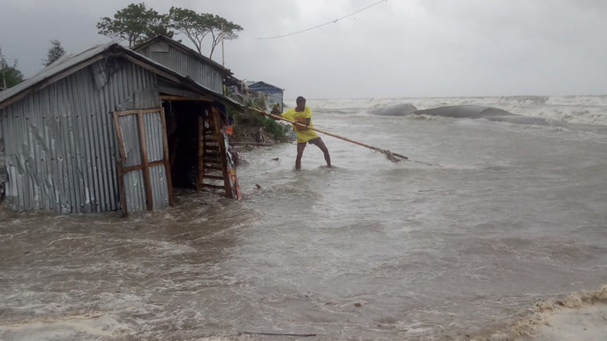
Cyclone Amphan in Bangladesh
Photo: Star

Amphan, one of the strongest cyclones formed in the Bay of Bengal, is likely to hit Bangladesh's coast with the maximum storm surge of 15 feet height above normal astronomical tide.

The storm surge due to the impact of the cyclone, set to make landfall in Bangladesh this evening, may inundate different parts of at least 14 coastal districts and their offshore islands and cause extended damage, according to the Met office.

Dr Mohammad Abul KalamMallik, meteorologist of Bangladesh Meteorological Department (BMD), said storm surge of 10 to 15 feet height above normal astronomical tide may happen as there will be full tide in the sea due to the end day of last quarter moon when the cyclone will make landfall. 

The low-lying areas of Satkhira, Khulna, Bagherhat, Jhalakathi, Pirojpur, Borguna, Patuakhali, Bhola, Barishal, Lakshmipur, Chandpur, Noakhali, Feni, Chattogram and their offshore islands and chars are likely to be inundated by the storm surge, he said.

Besides, the cyclone is likely to hit the coast with a wind speed of around 160km per hour with heavy to very heavy falls during its passage, intensifying the storm surge, according to the BMD. 

Indian Meteorological Department is predicting a storm surge of about 13 to 16 feet above astronomical tide in the low-lying areas of south and north 24 Pargana at the time of landfall.

It said the shape of the Bay of Bengal maximises storm surge at its northern end, since the region becomes narrower as storms spin further to the north, creating a funnel effect for the movement of water.

Weather experts said Amphan turned into an extremely severe or category 4 cyclone from category 1 within just 18 hours due to impacts of climate change. The high temperature helped the cyclone gain more strength, they said.

"We have never seen such high values until now," Dr Roxy Mathew Koll, a scientist at the Indian Institute of Tropical Meteorology, wrote on his Facebook page yesterday.

Dhaka Met office said with the sustained wind speed of up to 220 kilometres per hour, the cyclone was 345 km southwest off Mongla port, 370 km southwest off Payra port and 525 km southwest off Chattogram port till 9:00 am today.

As the cyclone has changed course, it may cross West Bengal-Bangladesh coast near Sundarbans this afternoon or evening, it said.

Mongla and Payra maritime ports and nearby coastal districts have been advised to hoist "great danger signal" number 10.

The Met office also asked that danger signal number six remain hoisted at Chattogram and Cox's Bazar maritime ports. 


Comments

Amphan approaching with 15ft high storm surge

Cyclone Amphan in Bangladesh
Photo: Star

Amphan, one of the strongest cyclones formed in the Bay of Bengal, is likely to hit Bangladesh's coast with the maximum storm surge of 15 feet height above normal astronomical tide.

The storm surge due to the impact of the cyclone, set to make landfall in Bangladesh this evening, may inundate different parts of at least 14 coastal districts and their offshore islands and cause extended damage, according to the Met office.

Dr Mohammad Abul KalamMallik, meteorologist of Bangladesh Meteorological Department (BMD), said storm surge of 10 to 15 feet height above normal astronomical tide may happen as there will be full tide in the sea due to the end day of last quarter moon when the cyclone will make landfall. 

The low-lying areas of Satkhira, Khulna, Bagherhat, Jhalakathi, Pirojpur, Borguna, Patuakhali, Bhola, Barishal, Lakshmipur, Chandpur, Noakhali, Feni, Chattogram and their offshore islands and chars are likely to be inundated by the storm surge, he said.

Besides, the cyclone is likely to hit the coast with a wind speed of around 160km per hour with heavy to very heavy falls during its passage, intensifying the storm surge, according to the BMD. 

Indian Meteorological Department is predicting a storm surge of about 13 to 16 feet above astronomical tide in the low-lying areas of south and north 24 Pargana at the time of landfall.

It said the shape of the Bay of Bengal maximises storm surge at its northern end, since the region becomes narrower as storms spin further to the north, creating a funnel effect for the movement of water.

Weather experts said Amphan turned into an extremely severe or category 4 cyclone from category 1 within just 18 hours due to impacts of climate change. The high temperature helped the cyclone gain more strength, they said.

"We have never seen such high values until now," Dr Roxy Mathew Koll, a scientist at the Indian Institute of Tropical Meteorology, wrote on his Facebook page yesterday.

Dhaka Met office said with the sustained wind speed of up to 220 kilometres per hour, the cyclone was 345 km southwest off Mongla port, 370 km southwest off Payra port and 525 km southwest off Chattogram port till 9:00 am today.

As the cyclone has changed course, it may cross West Bengal-Bangladesh coast near Sundarbans this afternoon or evening, it said.

Mongla and Payra maritime ports and nearby coastal districts have been advised to hoist "great danger signal" number 10.

The Met office also asked that danger signal number six remain hoisted at Chattogram and Cox's Bazar maritime ports. 


Comments

ফার্স্ট সিকিউরিটির ৫৬ শতাংশ ঋণ এস আলম সংশ্লিষ্ট প্রতিষ্ঠানের দখলে

এসব ঋণ চট্টগ্রামে ফার্স্ট সিকিউরিটি ইসলামী ব্যাংকের ২৪টি শাখা থেকে অনিয়মের মাধ্যমে বিতরণ করা হয়েছে।

৮ মিনিট আগে