Delimitation of maritime boundaries: Protecting our resources

Delimitation of maritime boundaries: Protecting our resources

Photo: star
Photo: star

Bangladesh is truly a maritime nation having a vast seaboard and wide arrays of interconnected river ways. The Sea Lanes of Communication (SLOC) that connects Bangladesh with the outside world is the umbilical cord that supports the country across a broad spectrum of her economic activities. The socio-economic lifeline is inseparably linked with the Bay of Bengal which provides passage to 95% of our trades and offers livelihood to almost thirty millions of peoples.  Such a reality was first appreciated by the great visionary leader, father of the nation Bangabandhu Sheikh Mujibur Rahman who decided to enact Territorial Water and Maritime Zones act 1974. It surprises many scholars and analysts today that the charter of the United Nation's Convention on Law of The Sea which was promulgated in 1982 was very much similar to most of the provisions of the territorial act which was enacted in Bangladesh eight years ago. Such was the marvel of his wisdom. Thirty five years later similar statesmanship and wisdom was demonstrated by Prime Minister Shekih Hasina when she decided for settlement of this issue through compulsory dispute settlement procedure by resorting to the International Tribunal on Law of the Sea (ITLOS).
On Wednesday 14 March 2012, the International Tribunal for the Law of the Sea issued its judgment on the dispute concerning Delimitation of the Maritime Boundary between Bangladesh and Myanmar.  The dispute concerned the delimitation of the territorial seas, exclusive economic zones and continental shelves of these two states in the Bay of Bengal.
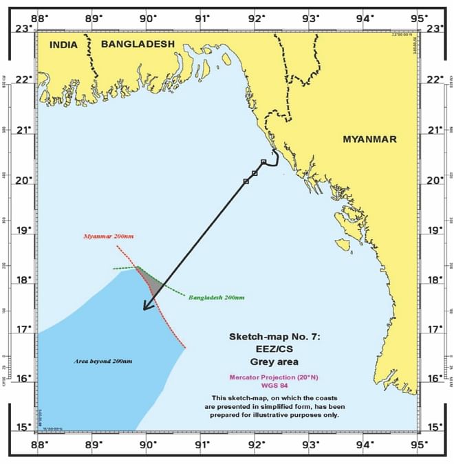
The Judgment is important in a number of respects. Firstly, it is the first dispute concerning maritime boundary delimitation decided by the International Tribunal for the Law of the Sea. Secondly, it is the first judgment of an international court or tribunal which directly addresses the delimitation of the continental shelf beyond 200 nautical miles.  The tribunal therefore had to deal with some novel legal issues in its judgment.
The verdict was accepted with enormous amount of enthusiasm and jubilation in Bangladesh on the pretext that the verdict of the tribunal overwhelmingly favored Bangladesh. Many of the enthusiasts went to the extent of commenting that the nation had won a battle at the bay. It indeed was a true milestone in the development history of Bangladesh. While much of the applause and accolade was justly appropriate and professionally acceptable there were other quarters in the country who continued to search for defects in the verdict. They pursued ceaseless campaign to denounce the accomplishment of the legal team and came up with a number of faults in the verdict. Many of them having little knowledge on the legal intricacies of equitable delimitation of maritime boundary unnecessarily criticized the verdict on trivial issues which were overly irrelevant. Throughout its judgment, the Tribunal stressed that the goal of maritime boundary delimitation was to deliver an equitable solution.  Although outcome of the verdict issued by ITLOS was unlikely to be a “winner takes all” scenario, but there were lot of caveats for Bangladesh in it to rejoice and celebrate. It thus may be prudent to put these issues in its professional context which will help everyone to make a true assessment about the achievement of Bangladesh in this legal encounter.
For the delimitation of the Territorial Sea, Bangladesh argued for any point on the line connecting the St. Martin's Island and Oyster Island after giving due effect  in favor of St. Martin's Island which is very much in line with the agreed minutes of 1974 that was reiterated in 2008. Bangladesh also reiterated about the full effects of St. Martin's Island as per the regime of Islands as stipulated in UNCLOS. Myanmar on the other hand argued that 1974 agreed minutes were nothing more than a conditional agreement reached at the level of the negotiators. Myanmar also took the stance that St. Martin's Island should not be given a full effect for defining the territorial sea. The tribunal accepted the claim of Bangladesh and gave a full effect to the St. Martin's Island considering its size and population and awarded Territorial Water to Bangladesh by drawing a 12 nautical miles (nm) arc from the southernmost point of St. Martin's Island. Bangladesh succeeded in achieving her claim of St. Martin's Island and won a territorial sea of 12 nautical mile around the St. Martin's Island. This is an accomplishment worth noting and exploiting further to gain more sea area.
For delimitation of Exclusive Economic Zone and Continental shelf, Bangladesh submitted to the tribunal to consider three geographical and geological features namely the double concavity of Bangladesh's coastline, the geographical feature of St. Martin's Island as a significant coastal island lying within 5 nm of the Bangladesh mainland and the Bengal depositional system. Bangladesh further argued that these features should be taken into account as a relevant circumstance in fashioning an equitable delimitation by applying angle bisector method for delimitation. On the other hand, Myanmar argued that there does not exist any relevant circumstance that may lead to an adjustment of the provisional equidistance line.
The Tribunal noted that the coast of Bangladesh, seen as a whole, is manifestly concave and portrays a classic example of a concave coast. The Tribunal further noted that, on account of the concavity of the coast in question, the provisional equidistance line produces a cut-off effect on

the maritime projection of Bangladesh and that the line if not adjusted would not result in achieving an equitable Solution. For equity, the Tribunal considered the issue of double concavity of the coastline of Bangladesh and proposed that the equidistance principle should be applied only as a provisional step and then the boundary will be adjusted to consider the issue of cut off effect due to concavity. The drawn boundary thus provided much more area to Bangladesh than stipulated in Myanmar's claim. While Bangladesh herself sought access to 1, 07, 00 square kilometers of area, she was awarded with an area of 1, 11, 631 square kilometers.
On the issue of continental shelf Myanmar claimed that the tribunal does not have the jurisprudence over deciding the continental shelf beyond 200 nautical miles. Besides she claimed that the continental shelf of Bangladesh does not extend beyond 200 nautical miles, so Bangladesh is not entitled to the continental shelf. Bangladesh on the other hand submitted that the tribunal has all the legal authority to delimit area of continental shelf. She also submitted material suggesting that Myanmar's continental shelf should be less than 200 nautical miles. Disregarding Myanmar's objection the tribunal asserted that it has full authority over deciding the continental shelf beyond 200 Nautical miles from the base line and decided to demarcate the continental shelf of two countries. The court also disregarded the objection of Myanmar and granted continental shelf to Bangladesh beyond 200 Nautical Miles.
Strategically Bangladesh earned a lot from this judgment. The judgment has unveiled a number of strategic opportunities to Bangladesh. In addition to the sovereignty of the large area that has been bestowed upon Bangladesh, it had also enhanced the image of Bangladesh in the international arena. She can now exploit these strategic opportunities in reshaping some of her foreign policy options in her favor. The precedence of this judgment would help Bangladesh in achieving her due share of the Bay of Bengal in the western front also.  
Political implications of this verdict are equally important. Firstly it would foster a long lasting bilateral relationship between Bangladesh and Myanmar. Given the fact that the verdict has brought an end to a problem that has hampered the economic development of both countries for more than three decades, they would be encouraged to cooperate on number relevant issues of national interests. The verdict would allow more trade between these two countries. Secondly, the delineation of the maritime boundary could also have implications for regional energy importers such as China and India, who have competed previously to secure gas from the region. Gas discoveries in the demarcated sea area and establishment of energy infrastructure in the bay would create the environment for better cooperation between the regional countries and forge stronger economic, strategic and political link with regional big players like India and china.
Lastly, the verdict will contribute in strengthening regional cooperation and the region will play more important role than predicted. It would greatly facilitate Asian connectivity through the indo pacific corridors.
Economic implications of this delimitation are countless. Few of the major ones will be highlighted in this article. Bangladesh now has sovereign right to explore, exploit, conserve, and manage living and non-living resources of water column, seabed and subsea strata and economic activities, such as the production of energy from the water, currents and winds within 200nm of EEZ.  It has exclusive right to carry out fishing in her area of jurisdiction and export to other countries. Bangladesh can effectively ensure conservation of fishery resources by enforcing appropriate regulations about the season for harvesting, types of vessel and equipment that can be used and institute cooperative measures regarding straddling stocks and highly migratory species. Through legislation it can also ensure that the living resources in the EEZ are not endangered by over exploitation, conservation of dependent and associated species, and sustainable harvesting of species. Bangladesh shall have the rights to explore and exploit all living resources in her area including the sedentary species like corals, scallops, sponges and mollusk. She also has the legal rights to explore nonliving resources of the sea bed and subsoil such as cobalt, copper, manganese, nickel, ferromanganese nodules, and gas hydrate deposit in the continental shelf extending beyond 200 Nautical Miles.

Photo: star
Photo: star

The Bay of Bengal is reported to be highly rich in hydrocarbon resources. It was proved by the Indian discoveries in the Krishna Godavari Basins and also by massive oil and gas finds in Myanmar. While official sources quote a figure of 100 trillion cubic feet of gas reserves in the region, unofficial estimates peg the reserves at 200 trillion cubic feet of gas.  The country can now start drilling for oil and gas within 200 nm and beyond 200nm out to sea. The discovery of new oil and gas will help the country to meet its domestic demands, and the government could also generate capital by allocating blocks to international companies for further exploration.
Various Implications which were discussed in the foregoing part of the article should be assessed prudently before making any rosy conclusion. I consider it just to serve a note of caution to the reader at the end to examine those possibilities pragmatically and deduce some policy options which shall help us to exploit our sea resources optimally. Because mere possession of these vast sea areas would be insignificant to Bangladesh unless the potentials of its huge resources are properly preserved and exploited.
Predominantly, governance of our sea area would be of utmost importance to conserve, contain, explore, exploit and manage the living and nonliving resources contained in our sea area. In addition, marinating safe and secure Sea Lanes of Communication would also be crucial to facilitate uninterrupted flow national and international trade. A highly collaborative effort would thus be needed where all the concern stakeholders would be actively involved and participate in all the maritime related activities.
A holistic approach would be needed to formulate common policy guidelines like a comprehensive maritime strategy. Under the auspices of this strategy all the concern maritime agencies would be able to conduct their operational activities in line with the maritime objectives of the country. Such a strategy will lay down the principles, procedures and practices of the management of the maritime resources with some details of responsibilities and functionalities.
Deliberate efforts should be made to grow Maritime Domain Awareness (MDA) among the general mass, policy makers and media and inform them about the usefulness of the sea and its resources and the need of its efficient management. Prevailing situation of sea blindness would gradually reduce once more and more institutions offer educational opportunities on maritime related subjects. This in turn will generate more number of educated and well informed personnel who would be more focused towards the sea borne activities.

Photo: star
Photo: star

Strengthening Maritime Infrastructure should be given priority. Revamping existing port facilities, establishing Deep Sea Port, promoting shipbuilding industry and facilitating operations of Bangladeshi owned merchant and fishing vessel and over all restructuring of various maritime organization are likely to pay rich dividends.
A national maritime coordination centre/cell/foundation would be very effective in coordinating the activities of all the maritime agencies during various stages of national contingencies, especially in peace and war. Such type of coordination cell/centre/foundation is in existence in many of our neighboring countries.
Equipping our maritime security agencies with appropriate capability would be another important policy decision which would have long lasting impact on the expansion of maritime activities and rapid growth of our economy. Capacity building of Bangladesh Navy and Bangladesh Coast Guard with appropriate hardware and manpower should be undertaken and the personnel should be trained and organized to meet up the future challenges of ensuring the safety and security of the users of sea. Special emphasis should be given on enhancement of sea surveillance and management of sea resources including nation building and disaster management.  

The author is Assistant Chief of Naval Staff (Personnel) in the  Naval Headquarters.


Comments

Delimitation of maritime boundaries: Protecting our resources

Delimitation of maritime boundaries: Protecting our resources

Photo: star
Photo: star

Bangladesh is truly a maritime nation having a vast seaboard and wide arrays of interconnected river ways. The Sea Lanes of Communication (SLOC) that connects Bangladesh with the outside world is the umbilical cord that supports the country across a broad spectrum of her economic activities. The socio-economic lifeline is inseparably linked with the Bay of Bengal which provides passage to 95% of our trades and offers livelihood to almost thirty millions of peoples.  Such a reality was first appreciated by the great visionary leader, father of the nation Bangabandhu Sheikh Mujibur Rahman who decided to enact Territorial Water and Maritime Zones act 1974. It surprises many scholars and analysts today that the charter of the United Nation's Convention on Law of The Sea which was promulgated in 1982 was very much similar to most of the provisions of the territorial act which was enacted in Bangladesh eight years ago. Such was the marvel of his wisdom. Thirty five years later similar statesmanship and wisdom was demonstrated by Prime Minister Shekih Hasina when she decided for settlement of this issue through compulsory dispute settlement procedure by resorting to the International Tribunal on Law of the Sea (ITLOS).
On Wednesday 14 March 2012, the International Tribunal for the Law of the Sea issued its judgment on the dispute concerning Delimitation of the Maritime Boundary between Bangladesh and Myanmar.  The dispute concerned the delimitation of the territorial seas, exclusive economic zones and continental shelves of these two states in the Bay of Bengal.

The Judgment is important in a number of respects. Firstly, it is the first dispute concerning maritime boundary delimitation decided by the International Tribunal for the Law of the Sea. Secondly, it is the first judgment of an international court or tribunal which directly addresses the delimitation of the continental shelf beyond 200 nautical miles.  The tribunal therefore had to deal with some novel legal issues in its judgment.
The verdict was accepted with enormous amount of enthusiasm and jubilation in Bangladesh on the pretext that the verdict of the tribunal overwhelmingly favored Bangladesh. Many of the enthusiasts went to the extent of commenting that the nation had won a battle at the bay. It indeed was a true milestone in the development history of Bangladesh. While much of the applause and accolade was justly appropriate and professionally acceptable there were other quarters in the country who continued to search for defects in the verdict. They pursued ceaseless campaign to denounce the accomplishment of the legal team and came up with a number of faults in the verdict. Many of them having little knowledge on the legal intricacies of equitable delimitation of maritime boundary unnecessarily criticized the verdict on trivial issues which were overly irrelevant. Throughout its judgment, the Tribunal stressed that the goal of maritime boundary delimitation was to deliver an equitable solution.  Although outcome of the verdict issued by ITLOS was unlikely to be a “winner takes all” scenario, but there were lot of caveats for Bangladesh in it to rejoice and celebrate. It thus may be prudent to put these issues in its professional context which will help everyone to make a true assessment about the achievement of Bangladesh in this legal encounter.
For the delimitation of the Territorial Sea, Bangladesh argued for any point on the line connecting the St. Martin's Island and Oyster Island after giving due effect  in favor of St. Martin's Island which is very much in line with the agreed minutes of 1974 that was reiterated in 2008. Bangladesh also reiterated about the full effects of St. Martin's Island as per the regime of Islands as stipulated in UNCLOS. Myanmar on the other hand argued that 1974 agreed minutes were nothing more than a conditional agreement reached at the level of the negotiators. Myanmar also took the stance that St. Martin's Island should not be given a full effect for defining the territorial sea. The tribunal accepted the claim of Bangladesh and gave a full effect to the St. Martin's Island considering its size and population and awarded Territorial Water to Bangladesh by drawing a 12 nautical miles (nm) arc from the southernmost point of St. Martin's Island. Bangladesh succeeded in achieving her claim of St. Martin's Island and won a territorial sea of 12 nautical mile around the St. Martin's Island. This is an accomplishment worth noting and exploiting further to gain more sea area.
For delimitation of Exclusive Economic Zone and Continental shelf, Bangladesh submitted to the tribunal to consider three geographical and geological features namely the double concavity of Bangladesh's coastline, the geographical feature of St. Martin's Island as a significant coastal island lying within 5 nm of the Bangladesh mainland and the Bengal depositional system. Bangladesh further argued that these features should be taken into account as a relevant circumstance in fashioning an equitable delimitation by applying angle bisector method for delimitation. On the other hand, Myanmar argued that there does not exist any relevant circumstance that may lead to an adjustment of the provisional equidistance line.
The Tribunal noted that the coast of Bangladesh, seen as a whole, is manifestly concave and portrays a classic example of a concave coast. The Tribunal further noted that, on account of the concavity of the coast in question, the provisional equidistance line produces a cut-off effect on

the maritime projection of Bangladesh and that the line if not adjusted would not result in achieving an equitable Solution. For equity, the Tribunal considered the issue of double concavity of the coastline of Bangladesh and proposed that the equidistance principle should be applied only as a provisional step and then the boundary will be adjusted to consider the issue of cut off effect due to concavity. The drawn boundary thus provided much more area to Bangladesh than stipulated in Myanmar's claim. While Bangladesh herself sought access to 1, 07, 00 square kilometers of area, she was awarded with an area of 1, 11, 631 square kilometers.
On the issue of continental shelf Myanmar claimed that the tribunal does not have the jurisprudence over deciding the continental shelf beyond 200 nautical miles. Besides she claimed that the continental shelf of Bangladesh does not extend beyond 200 nautical miles, so Bangladesh is not entitled to the continental shelf. Bangladesh on the other hand submitted that the tribunal has all the legal authority to delimit area of continental shelf. She also submitted material suggesting that Myanmar's continental shelf should be less than 200 nautical miles. Disregarding Myanmar's objection the tribunal asserted that it has full authority over deciding the continental shelf beyond 200 Nautical miles from the base line and decided to demarcate the continental shelf of two countries. The court also disregarded the objection of Myanmar and granted continental shelf to Bangladesh beyond 200 Nautical Miles.
Strategically Bangladesh earned a lot from this judgment. The judgment has unveiled a number of strategic opportunities to Bangladesh. In addition to the sovereignty of the large area that has been bestowed upon Bangladesh, it had also enhanced the image of Bangladesh in the international arena. She can now exploit these strategic opportunities in reshaping some of her foreign policy options in her favor. The precedence of this judgment would help Bangladesh in achieving her due share of the Bay of Bengal in the western front also.  
Political implications of this verdict are equally important. Firstly it would foster a long lasting bilateral relationship between Bangladesh and Myanmar. Given the fact that the verdict has brought an end to a problem that has hampered the economic development of both countries for more than three decades, they would be encouraged to cooperate on number relevant issues of national interests. The verdict would allow more trade between these two countries. Secondly, the delineation of the maritime boundary could also have implications for regional energy importers such as China and India, who have competed previously to secure gas from the region. Gas discoveries in the demarcated sea area and establishment of energy infrastructure in the bay would create the environment for better cooperation between the regional countries and forge stronger economic, strategic and political link with regional big players like India and china.
Lastly, the verdict will contribute in strengthening regional cooperation and the region will play more important role than predicted. It would greatly facilitate Asian connectivity through the indo pacific corridors.
Economic implications of this delimitation are countless. Few of the major ones will be highlighted in this article. Bangladesh now has sovereign right to explore, exploit, conserve, and manage living and non-living resources of water column, seabed and subsea strata and economic activities, such as the production of energy from the water, currents and winds within 200nm of EEZ.  It has exclusive right to carry out fishing in her area of jurisdiction and export to other countries. Bangladesh can effectively ensure conservation of fishery resources by enforcing appropriate regulations about the season for harvesting, types of vessel and equipment that can be used and institute cooperative measures regarding straddling stocks and highly migratory species. Through legislation it can also ensure that the living resources in the EEZ are not endangered by over exploitation, conservation of dependent and associated species, and sustainable harvesting of species. Bangladesh shall have the rights to explore and exploit all living resources in her area including the sedentary species like corals, scallops, sponges and mollusk. She also has the legal rights to explore nonliving resources of the sea bed and subsoil such as cobalt, copper, manganese, nickel, ferromanganese nodules, and gas hydrate deposit in the continental shelf extending beyond 200 Nautical Miles.

Photo: star
Photo: star

The Bay of Bengal is reported to be highly rich in hydrocarbon resources. It was proved by the Indian discoveries in the Krishna Godavari Basins and also by massive oil and gas finds in Myanmar. While official sources quote a figure of 100 trillion cubic feet of gas reserves in the region, unofficial estimates peg the reserves at 200 trillion cubic feet of gas.  The country can now start drilling for oil and gas within 200 nm and beyond 200nm out to sea. The discovery of new oil and gas will help the country to meet its domestic demands, and the government could also generate capital by allocating blocks to international companies for further exploration.
Various Implications which were discussed in the foregoing part of the article should be assessed prudently before making any rosy conclusion. I consider it just to serve a note of caution to the reader at the end to examine those possibilities pragmatically and deduce some policy options which shall help us to exploit our sea resources optimally. Because mere possession of these vast sea areas would be insignificant to Bangladesh unless the potentials of its huge resources are properly preserved and exploited.
Predominantly, governance of our sea area would be of utmost importance to conserve, contain, explore, exploit and manage the living and nonliving resources contained in our sea area. In addition, marinating safe and secure Sea Lanes of Communication would also be crucial to facilitate uninterrupted flow national and international trade. A highly collaborative effort would thus be needed where all the concern stakeholders would be actively involved and participate in all the maritime related activities.
A holistic approach would be needed to formulate common policy guidelines like a comprehensive maritime strategy. Under the auspices of this strategy all the concern maritime agencies would be able to conduct their operational activities in line with the maritime objectives of the country. Such a strategy will lay down the principles, procedures and practices of the management of the maritime resources with some details of responsibilities and functionalities.
Deliberate efforts should be made to grow Maritime Domain Awareness (MDA) among the general mass, policy makers and media and inform them about the usefulness of the sea and its resources and the need of its efficient management. Prevailing situation of sea blindness would gradually reduce once more and more institutions offer educational opportunities on maritime related subjects. This in turn will generate more number of educated and well informed personnel who would be more focused towards the sea borne activities.

Photo: star
Photo: star

Strengthening Maritime Infrastructure should be given priority. Revamping existing port facilities, establishing Deep Sea Port, promoting shipbuilding industry and facilitating operations of Bangladeshi owned merchant and fishing vessel and over all restructuring of various maritime organization are likely to pay rich dividends.
A national maritime coordination centre/cell/foundation would be very effective in coordinating the activities of all the maritime agencies during various stages of national contingencies, especially in peace and war. Such type of coordination cell/centre/foundation is in existence in many of our neighboring countries.
Equipping our maritime security agencies with appropriate capability would be another important policy decision which would have long lasting impact on the expansion of maritime activities and rapid growth of our economy. Capacity building of Bangladesh Navy and Bangladesh Coast Guard with appropriate hardware and manpower should be undertaken and the personnel should be trained and organized to meet up the future challenges of ensuring the safety and security of the users of sea. Special emphasis should be given on enhancement of sea surveillance and management of sea resources including nation building and disaster management.  

The author is Assistant Chief of Naval Staff (Personnel) in the  Naval Headquarters.


Comments

আব্দুল্লাহপুর, উত্তরা, তুরাগ নদী, সভা-সমাবেশ, ঢাকা মেট্রোপলিটন পুলিশ,

উত্তরা-আব্দুল্লাহপুর-তুরাগ এলাকায় অনির্দিষ্টকালের জন্য সভা-সমাবেশ নিষিদ্ধ

আজ বুধবার বিকেল দুইটা থেকে পরবর্তী নির্দেশ না দেওয়া পর্যন্ত এই নিষেধাজ্ঞা বহাল থাকবে।

১ ঘণ্টা আগে