Interviews

Our embankments are contributing to floods, not stopping them
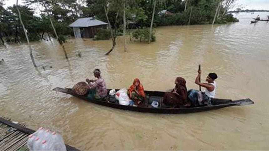
An immediate task for the government is to get ready for helping the affected people with rehabilitation and recovery. Photo: Star
Dr S Nazrul Islam

Dr S Nazrul Islam, founder of Bangladesh Environment Network (BEN) and Vice President of Bangladesh Poribesh Andolon (BAPA), speaks with Naznin Tithi of The Daily Star about the causes behind the devastating floods in Sylhet and Sunamganj, and what the government must do to avoid such disasters in the future.


What was supposed to be a seasonal flash flood – which is a seasonal phenomenon in the haor area – turned out to be a severely catastrophic flood. What factors, do you think, contributed to this year's devastating floods in Sylhet and Sunamganj?

There are three types of factors: Global, regional, and domestic. The global factor is climate change, which is causing the rainfall to increase and become erratic. The regional factor has several dimensions. One is the changes in land use, such as denouement of forest cover, spread of mining operations, etc., that have taken place in Meghalaya and other states that lie on the northern border of the Sylhet division. As a result of these changes, rainwater from India quickly passes to Bangladesh, containing more sediments, which have been increasingly filling up riverbeds in this division. The second is the intervening structures in the transboundary rivers that India has constructed. There are 16 rivers in this area that are recognised and listed as transboundary by the Indo-Bangladesh Joint River Commission (JRC). In addition, there are about 30 smaller rivulets and streams that are also transboundary. India has constructed intervening structures on most of these watercourses unilaterally and also manages them more or less unilaterally. It uses them to hold water when needed, but whenever there is a heavy downpour it opens up the vents of the barrages, causing a heavy and quick onrush of sediment-laden water to Bangladesh.  The main domestic factor is Bangladesh's faulty approach to rivers that has been in practice for about seven decades now. This is the Cordon approach, under which flood plains are cordoned off from rivers through the construction of embankments. In addition to embankments, widespread construction of roads, highways, settlements, and other structures have proceeded without necessary awareness about the necessity of keeping enough space for the storage and passage of flood water. This has been particularly damaging for the Sylhet Basin, which is a depression with very low elevation and is further sinking because of tectonic movements. What we are seeing now in Sylhet, Sunamganj, Netrokona, and Kishoreganj area is a combined effect of these three types of factors.

Do we have any scientific forewarning systems that can alert people and the concerned government agencies about the possibility of such severe flooding?

There are some forewarning systems concerning the major rivers, such as the Ganges and the Brahmaputra. However, such systems are lacking for the numerous transboundary rivers, rivulets, and streams that flow from Meghalaya, Assam, Tripura states of India into Bangladesh. There is also less time for forewarning and preparation because of the special feature of the terrain, whereby rivers descend suddenly from the Meghalaya hills to the Sylhet depression.

Many have been blaming the unplanned development works in the haor area to be one of the major factors behind the floods. What's your take on this?

Yes, as I said, these unplanned development works in the haor area have become a major cause for the floods, because, first of all, they have reduced the space for water to spread out, and second, they have constricted the passageway for water to flow down quickly to the south. In addition to the numerous structures that have been built in the haor area, there are the bridges across the Kalni and Meghna Rivers in the Bhairab Bazar area which are too narrow to let the water pass through quickly. Water from the entirety of Sylhet and the eastern part of the Mymensingh division and also from the Bhairab Bazar area ultimately passes through the Kalni-Meghna channel. Constrictions on this channel in the form of these narrow bridges have now created a bottleneck for the passage of water, aggravating flooding in the area.

The ecology of the haor area in Sylhet, Sunamganj, and Kishoreganj is quite different from the rest of the country. Do we also need a different flood and river management system for these areas?

Yes, the haor area, geologically known as the Sylhet Depression or Sylhet Basin, is a special area of Bangladesh with a different ecology. The average elevation of this area is only about five metres above sea level. This elevation is also decreasing over time, because the Indian Plate is pushing and slipping under the Eurasian Plate, a process that originally led to the creation of the Himalayan Mountains more than 50 million years ago. As a result, the Sylhet Basin is pushed down relative to the Meghalaya Massif along the Dauky Fault Line. The Cordon approach is therefore particularly inappropriate for the Sylhet Basin. We have been pointing to this aspect of the situation for many years now. We have been arguing for the minimisation of structures in the haor area and for constructing roads and highways in this area only in the form of causeways, that is, as elevated roads built on pillars. This would meet both the need for transportation and the need for passageways for water to flow away. Similarly, we have been arguing for special care in keeping the rivers of the area free of obstructions and ensuring their adequate cross-sectioning. Also, special care is needed in the maintenance of the submersible embankments that have been constructed in this area for protection against flash and early floods. Unfortunately, the authorities did not heed our recommendations and warnings. They went ahead with the construction of many new roads and highways. In some cases, some submersible sections were added and bridges and culverts were allowed, but obviously these were not adequate. These and other constricting structures need to be removed and all roads and highways in the haor area need to be rebuilt as causeways.

Right now, where should the government focus to contain the flood situation?

There are several immediate tasks for the government. The first is to provide relief and other help that the affected people need for survival. The second is to do whatever can be done to let the water pass away quickly. It has been reported that, in many cases, cuts in roads and highways are being made to allow for this. There should not be any hesitation in doing so. The third immediate task is to get ready for helping the affected people with rehabilitation and recovery. Another task for the government is to realise that the Cordon approach is not appropriate for Bangladesh. What the country needs is the Open approach, which is the only way in which Bangladesh can survive in the face of climate change. Under this approach, floodplains and tidal plains would be kept open to rivers and as unobstructed as possible so that flood level remains low and water can recede quickly. In my recent book, Water Development in Bangladesh: Past Present & Future, I have offered a comprehensive argument explaining why a switch from the Cordon to the Open approach is necessary and has become urgent for Bangladesh. I hope the current floods in Sylhet will act as a rude awakening and persuade the government to see the merit of this argument and adopt the Open approach as the overarching principle for water development efforts in the country.

Comments