“Bangladesh needs to put forward the ‘transit in exchange for rivers’ formula as the framework for Indo-Bangladesh negotiations”

Congratulations on the publication of your latest book titled 'Water Development in Bangladesh: Past, Present, & Future'. Would you kindly provide us with a brief summary of the topics covered in your book?

I have been writing about water development issues since the 1988 flood and, over time, developed a conceptual framework for discussing these issues. Earlier, I presented it my book, "Rivers and Sustainable Development: Alternative Approaches and Their Implications," published by the Oxford University Press in 2020. Though this book received considerable international acclaim, it remained largely inaccessible to readers in Bangladesh. Also, since its scope was global, it could not provide a detailed discussion of water issues of Bangladesh. The current book, Water Development in Bangladesh – Past, Present & Future, can be considered as a sequel. It begins with an overall picture of the land and water situation of Bangladesh and then provides a summary version of the conceptual framework. The book next delves into a detailed analysis of Bangladesh's past water development experience, draws lessons from it, and discusses the future.
Could you provide some insights into the conceptual framework you have established in your work?
The conceptual framework is based on four concepts, namely the "Commercial" and "Ecological" approaches to rivers and their respective derivatives, the "Cordon" and "Open" approaches. According to the Commercial approach, rivers are just another resource that need to be exploited to the full for various commercial gains. In a deltaic setting, such as of Bangladesh, the derivative of the Commercial approach is the Cordon approach, which suggests that river overflows have to be prevented from reaching floodplains so that the commercial value of the latter can be reaped fully. Unfortunately, these are myopic approaches and they ignore rivers role as the lynchpin in the earth's hydrological cycle and in creating and sustaining the unique ecologies in their basins. The Ecological approach pays attention to these important roles of rivers takes a more long-run and holistic view. In particular, it encourages the preservation of the natural volume and direction of river flows. In a deltaic setting, such as of Bangladesh, the derivative of the Ecological approach is the Open approach which calls for keeping floodplains open to river channels so that annual river overflow can reach and rejuvenate the soil and water bodies in the floodplains each year. The fundamental proposition of my book is that Bangladesh needs to switch from the Cordon to the Open approach.
How do you assess the impact of colonial ideologies on our present-day river system, considering that they played a significant role in shaping it?
Indeed, the first major intervention in the river system and floodplains of Bangladesh took place during the British colonial period in the form of the railway system. Most rivers in Bangladesh flow in a north-south direction, and the railway lines that also run in this direction represent a less severe obstruction to longitudinal water flows on the floodplains, though they too obstruct the transverse flows. However, many railway lines run in an east-west direction, and these act as frontal obstructions. It is not surprising that many railway lines were later used as embankments in various cordon projects. Another negative development during the colonial period was the neglect of the irrigation system based on river overflows. This has been aptly described by William Willcocks, the famous British water engineer, in his well-known Lectures on the Ancient System of Irrigation in Bengal. In these Lectures, Willcocks shows that a vibrant irrigation system, based on man-made canals, prevailed in pre-colonial Bengal. These canals carried silt-laden river overflows to the fields. According to Willcocks, it was this irrigation system that made Bengal prosperous in pre-colonial times. He lamented that this system had fallen into disuse, and he argued strongly for its revival. The Open approach that I advocate in my book has some similarity with Willcocks' suggestions.

The implementation of the polder construction system during the Pakistan era has undoubtedly ensured agricultural prosperity in the southern regions of Bangladesh. However, it has also resulted in significant problems in certain areas, such as Jessore, Khulna, and Satkhira. What is your evaluation of this system and its impact on the region?
Yes, the entire coastal region was empoldered during the Pakistan period under the Coastal Embankment Project (CEP). About 140 polders were constructed, requiring more than 5,000 km of embankments. Polders were a Dutch idea and the Dutch Professor J. Thijsee, who was a consultant to the project, played an important role. Initially, the CEP was financed by the Food and Agriculture Organization (FAO) of the United Nations and later the World Bank and a few other organizations played a more active role. You are right that initially the polders appeared to be successful. The cropping intensity and total crop output increased. However, the negative effects caught up soon. The root of the problems lay in the termination of sedimentation inside the polders. As you know, rivers bring about one billion tons of sediment each year to Bangladesh. A significant part of it used to be deposited on the coastal areas and raised their elevation. Coastal embankments prevented this process. As a result, the land elevation inside the polders stopped increasing and actually fell (due to soil compaction, etc.). Instead, the sediment collected more on the river beds, raising their elevation. As a result, outlets for draining the water accumulated inside the polders became clogged, causing waterlogging, particularly in various parts of the Khulna Division, as you have mentioned. What we need is to modify the polders so that sediment can enter and raise the elevation of the coastal areas.
What is your perspective on the current discussions about the relationship between climate change and water management?
In fact, climate change and sea level rise have made the modifications of the polders even more urgent. Currently, the sea level along Bangladesh's coast is rising by about 0.5 to 1.3 cm per year. A significant part of Bangladesh's coastal area is predicted to be submerged by further sea level rise. However, scholars estimate that the elevation of Bangladesh's coast could rise by about 2 cm per year if sediment could spread on it. So, by restoring the sedimentation, Bangladesh can protect its coastal region from getting submerged. Coastal embankments need to be converted from permanent into seasonal. The coastal people in the past used Ashtomashi (eight months long) bandhs to cope with the seasonality of river flows. Reverting to Ashtomashi bandhs will allow sediment to get inside the polders during the four rainy months and prevent saline water from getting inside during the eight lean months. There are many other ways in which the Open approach can help Bangladesh to confront the adverse effects of climate change. These are discussed in detail in Chapter 14 of the book.

How do you view the history of the construction of the Farakka Barrage and its consequences in this region?
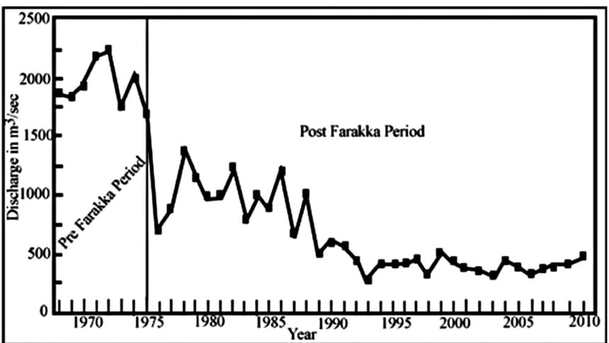
The Farakka Barrage is the largest intervention made by India in an international river that flows into Bangladesh. This barrage enables India to divert up to 40,000 cusecs of water from the Ganges River. Its main purpose was ostensibly to flush out sediment from the Hoogly River and to keep Kolkata functioning as a sea port. However, Kapil Bhattacharya, the Chief Engineer of West Bengal at the time of the barrage's inception, opposed it. He pointed out that structures built under the Damodar Valley Project were the primary cause of the Kolkata port's siltation and that the Farakka Barrage would not solve the problem. Unfortunately, Mr. Bhattacharya was removed from his position because of his opposing views. However, history has proven him correct. Farakka has not succeeded in ensuring Kolkata's viability as a sea port, while it has caused severe damage to the rivers of Bangladesh. Most of the distributaries of the Ganges River flowing through Bangladesh have dried up. Despite the 1996 Indo-Bangladesh Ganges water-sharing treaty, the dry season flow of the river in Bangladesh has not increased. Additionally, the Farakka Barrage has trapped about 300 million tons of sediment at its head, leading to flooding and bank erosion in Bihar. A movement has therefore developed in India, led by Nitish Kumar, Chief Minister of Bihar, calling for the demolition of the Farakka Barrage, and Bangladesh should support this demand. The impact of the Farakka Barrage on both India and Bangladesh is discussed in detail in Chapter 13 of the book.
How can Bangladesh best engage with India to promptly resolve water-sharing issues of rivers like Teesta and others?
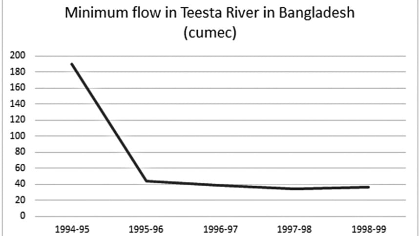
We have a worse problem with the Teesta River. India has constructed the Gajoldoba Barrage to divert the water of this river for irrigation in a huge area (about 1 million hectares) of West Bengal. The Gajoldoba Barrage is also supposed to be a part of India's River Linking Project, whose main goal is to divert the Brahmaputra flow to western and southern India. While the diversion of the Ganges flow by the Farakka Barrage is limited to the maximum of 40,000 cusec, which is the capacity of the feeder canal, there is virtually no limit to the diversion of Teesta water that India can carry out using the Gajoldoba Barrage. India is also planning to construct another 15 dams and barrages on the upstream reaches of the Teesta River and its tributaries. Thus, India has created a ground reality whereby there is practically no dry season flow left for Bangladesh. The much-talked-about Teesta Treaty between Bangladesh and India has practically become a mirage because the scope for a meaningful Teesta treaty no longer exists.
Bangladesh, therefore, needs to rethink its strategy of river-related negotiations with India. So far, it has depended mostly on India's goodwill. However, this has not yielded satisfactory results for Bangladesh. What is necessary is to negotiate on the basis of interests. While Bangladesh has interests in the restoration of the full natural flows of the international rivers, India also has interests in getting transit and transshipment facilities through Bangladesh to its seven northeastern states. Bangladesh, therefore, needs to put forward the "Transit in exchange for rivers" formula as the framework for Indo-Bangladesh negotiations. This formula is mutually beneficial for Bangladesh and India.
In addition, Bangladesh needs to sign the United Nations Convention of 1997 on the Non-navigational Uses of International Rivers. This Convention spells out the rights and responsibilities of co-riparian countries. Bangladesh can use this Convention to argue for its rights as the lower riparian country both in the bilateral negotiations with India and in international forums.

Can Bangladesh take any actions within its borders independently, without waiting for a mutually acceptable agreement with India on the Teesta River?
Yes, it can. First of all, the government needs to realize that the proposed Teesta River Comprehensive Management and Restoration Project (TRCMRP), promoted by Power-China company, will not provide a sustainable solution. Under this project, the average width of the Teesta River is to be reduced to one-third of its current size (from about 3 km to 0.8 km), and its depth is to be increased from 5 to 10 meters through capital dredging. However, the Teesta River carries about 50 million tons of sediment annually, nullifying the effect of dredging, which will eventually cause catastrophic flooding by overtopping or breaching the embankments. It will be difficult to constrain a flashy, braided river to artificial narrow confines in an alluvial fan. Instead, what needs to be done is to rejuvenate the entire Teesta Basin by reconnecting it with its 12 tributaries, distributaries, small rivulets, canals, lakes, and ponds. This will serve two purposes: first, these water bodies will absorb and store excess summer and sudden flows, and second, the stored water will flow back to the Teesta River during the lean months, ensuring the minimum environmental flow. Chapter 17 provides details regarding both TRCMRP and the alternative proposal.
What is your opinion on the Bangladesh Delta Plan 2100, recently developed by the government? Do you believe it offers the appropriate guidance for future water development endeavors?
The government's initiative to formulate the Bangladesh Delta Plan 2100 generated some enthusiasm and brought about more transparency and public consultations in the process. However, in the end, the effort proved to be disappointing for several reasons, discussed in detail in Chapter 16 of the book. In particular, it failed to learn from Bangladesh's past experience, conduct any original research, and remained influenced by old Dutch notions of river management that are unsuitable for Bangladesh's conditions. Consequently, the Delta Plan failed to develop its own work plan. At the end of the exercise, it requested that implementing agencies submit proposals they already had. Out of 123 submitted projects, the Delta Plan selected 80, failing to offer a new direction. Essentially, it provided what is called "old wine in a new bottle." Therefore, it is necessary to revisit the entire Delta Plan.
The interview was taken by Naznin Tithi and Priyam Paul of The Daily Star.

 For all latest news, follow The Daily Star's Google News channel.


Comments