Weekend Read

High Barind running out of water
New study paints a grim picture of groundwater depletion in the region

Due to decades of excessive water extraction, over 40 percent of unions in the high Barind region are facing severe groundwater depletion.

The situation is worsening due to climate change and the affected regions are expanding, leaving little access to water for drinking and irrigation, says a recent study conducted by the Institute of Water Modeling (IWM) on behalf of the Water Resources Planning Organisation (WARPO).

Covering three districts -- Rajshahi, Chapainawabganj and Naogaon -- the study, titled "Hydrological investigation and modelling of the state of surface and groundwater resources in the high Barind region", began in 2018 and was approved by WARPO last month.

The final report, financed jointly by the government and Swiss Agency for Development and Cooperation (SDC), is expected to be published in early August, said Md Rezaul Maksud Jahedi, director general of WARPO.

To address this critical situation, the study recommends using alternative surface water sources and promoting the combined use of groundwater and surface water in the affected areas.

The high Barind region, already considered a hotspot in the Delta Plan 2100, must take immediate action to preserve its water resources, said Prof Chowdhury Sarwar Jahan, a key expert involved in reviewing the study.

"It's important to manage the depleting resources promptly, as the livelihoods of people in Barind area heavily depend on groundwater," he added.

According to the study's findings, back in 1985 and 1990, the groundwater table depth in the region was around eight metres in most areas, with some spots reaching up to 21 metres in Gomostapur and Tanore upazilas.

However, due to excessive extraction for various purposes like drinking, irrigation, pisciculture, and industries, by 2010, the average depth had increased beyond 15 metres.
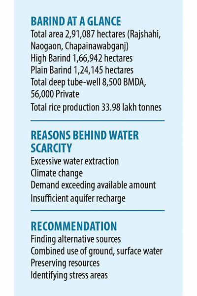
By 2021, the average depth reached 18 metres across a wider area, and in specific spots like Gomostapur of Chapainawabganj, it even  reached up to 46.87 metres.

Mentionable, the increase in depth signifies groundwater depletion .

The study also highlights that less rainfall and increased evaporation caused by climate change has contributed to reduction of groundwater recharge.

IDETIFYING WATER STRESS AREAS

The study conducted a comprehensive assessment of the aquifers (sediment saturated with groundwater. Groundwater enters an aquifer as precipitation seeps through the soil. It can move through the aquifer and resurface through springs and well) in the high Barind region, evaluating actual recharge and safe yield levels to determine water stress conditions across 25 upazilas.

Groundwater recharge is a hydrologic process, where water moves downward from surface water to groundwater. Recharge is the primary method through which water enters an aquifer.

At least 87 unions, which account for 40.65 percent of the total 214 unions in the region, were classified as falling into the two most critical categories of very high and high water stress areas. Water stress occurs its demand exceeds the available amount during a certain period or when poor quality restricts its use. It is often caused due to groundwater depletion.

Alarmingly, at least 87 unions, which account for 40.65 percent of the total 214 unions in the region, were identified as falling into the two most critical categories of very high and high water stress areas.

Water stress occurs when its demand exceeds the available amount during a certain period or when poor quality restricts its use. It is often caused due to groundwater depletion.

These unions experienced a concerning pattern where water levels declined from the previous monsoon to the next, indicating insufficient aquifer recharge. Among the hardest-hit areas were the entire Porsha and Nachol upazilas, where groundwater depletion was most severe.

The same category of very high water stress areas also includes additional 37 unions in nine upazilas, such as Godagari, Tanore, Gomostapur, Niamatpur, and Sapahar, also fell into the category of very high water stress areas.

Another 40 unions were identified as high water stress areas while 65 unions were identified as moderate ones, where the water resources are under considerable pressure.

On a somewhat positive note, the region does have 28 unions classified under low water stress and 34 under very low water stress categories, where the water crisis has not yet reached critical levels.

AQUIFIER ZONES

The study reveals that the region mainly consists of single or double aquifers, except for a few outer areas that have multiple aquifers.

Surprisingly, at Tetulia, Chaor, and Ganguria unions under Porsha and Sapahar upazilas, no aquifers were found at a drilling depth of 445 metres.

In Badhair union of Tanore, Nachol, parts of Chapainawabganj Sadar, and Gomastapur upazilas, there exists only one thin aquifer, ranging from six to 16 metres in thickness at a depth of 426 metres, serving as the sole water source.

The study highlights that some groundwater samples show elevated levels of bicarbonate, iron, and manganese beyond permissible standards, with arsenic contamination limited to Ranihati union.

RECOMMENDATIONS

To address these issues promptly, the study proposes excavation of surface water reservoirs and emphasises the re-excavation of existing beels and ponds.

Additionally, the report recommends promoting crop diversification as an alternative to water-intensive Boro crops in the areas most affected by water stress.

Finally, the study advises implementing artificial recharge of groundwater to replenish and maintain the aquifers in the region.

Comments

অব্যাহতিপ্রাপ্ত শিক্ষানবিশ এসআইদের সচিবালয়ের সামনে অবস্থান

এসময় কেউ কেউ স্লোগান দিচ্ছিলেন, ‘লাল সবুজের বাংলায়, বৈষম্যের ঠাঁই নাই’।

৬ মিনিট আগে