Cyclone Dana likely to make landfall on Oct 24

A powerful cyclonic storm, named Cyclone Dana, is likely to make landfall along the coasts of Bangladesh and India on October 24, posing a severe threat to the coastal regions.
The cyclone, which developed from a low-pressure system over the Bay of Bengal, is predicted to bring heavy winds and significant storm surges, according to the Indian Meteorological Department (IMD).
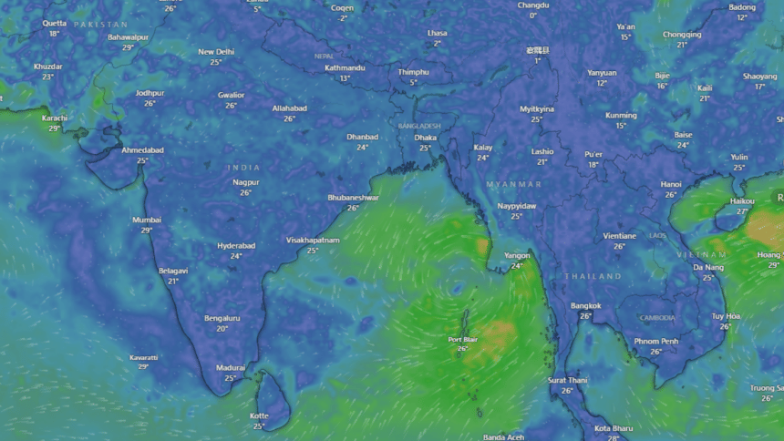
Today, the IMD said that the cyclonic circulation over the Andaman Sea intensified into a low-pressure area, expected to develop into a cyclonic storm by October 23.
Low Pressure Area formed over eastcentral Bay of Bengal and adjoining North Andaman Sea
Under the influence of yesterday's upper air cyclonic circulation over North Andaman Sea and adjoining eastcentral & southeast Bay of Bengal, a Low Pressure Area formed over the Eastcentral… pic.twitter.com/qtnzXTGZLO
— India Meteorological Department (@Indiametdept) October 21, 2024
Cyclone Dana is likely to hit the coasts of Odisha and West Bengal before moving inland, with the districts of Satkhira and Khulna in Bangladesh, as well as West Bengal's Midnapore and South 24 Parganas, among the areas expected to experience the brunt of the storm.
Potential Impact on Bangladesh
Using satellite data from Japan, meteorologists indicated that the storm's intensity increased over the past 24 hours.
As of this evening, the system had intensified into a well-marked low-pressure area, located at approximately 15°N latitude and 92°E longitude, with wind speeds around 50 km/h near the storm's centre.
Dana could make landfall between midnight on October 23 and 6:00pm on October 24, potentially impacting Khulna division in Bangladesh as a severe cyclone. Wind speeds of 110 to 120km per hour are anticipated, which could cause significant damage to infrastructure and crops.
Storm Surge Warnings
The most severe threat from Cyclone Dana could be the storm surge, especially if the landfall coincides with high tide.
Meteorologists warned that the coastal districts of Satkhira, Khulna and Bagerhat could experience surges of 7 to 8 feet above normal tidal levels. In the event of low tide, surges of 3 to 5 feet are expected.
Further south, the districts of Barguna, Patuakhali and Bhola may face storm surges ranging from 5 to 6 feet at high tide and 1 to 3 feet during low tide.
Other coastal regions such as Noakhali and Chattogram could see surges between 3 to 5 feet, while Cox's Bazar may experience slightly lower surges of 2 to 4 feet.
Authorities Urge Vigilance
Authorities have called on residents in coastal areas to remain vigilant and prepare for possible evacuations.
Local officials are working on preemptive measures to mitigate the impact of potential flooding and high winds, while shelters are being readied to accommodate evacuees.
Dana's landfall and the ensuing storm surge could disrupt daily life in affected regions, and residents are advised to follow local warnings closely as the storm approaches.
Authorities are continuing to monitor the situation, and updates will be issued as new information becomes available.

 For all latest news, follow The Daily Star's Google News channel.


Comments