Weekend Read

Crown jewels of Bengal
Tourist attractions in North Bengal
Photo: Mostafa Shabuj, Nayem Islam, Abul Kalam Azad, Tushar Dutta.

Scattered across Bangladesh are countless archaeological treasures that reveal its prosperous past. While time has erased some, many remain hidden beneath the earth, awaiting discovery. Among the surviving remnants are ancient fortresses, temples, mosques, monasteries and so on -- testaments to the region's rich history and cultural legacy.

The ancient fort city of Pundranagara (now Mahasthangarh) in Bogura and the Somapura Mahavihara (now Paharpur) in Naogaon district stand out as remarkable examples of Bengal's thriving urban civilization.

Of Bangladesh's 536 protected archaeological sites, 256 are in the northern districts, according to the Department of Archaeology. Among these, Mahasthangarh and Paharpur Buddhist Vihara are the most notable.
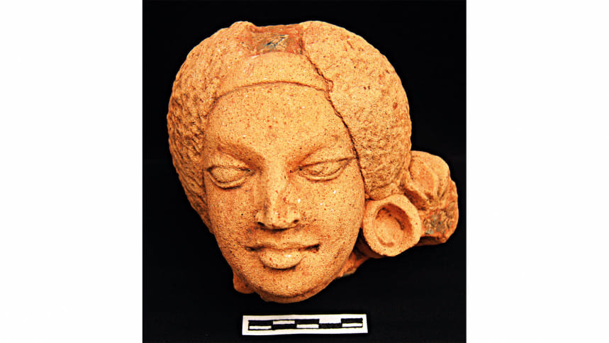
Terracotta head excavated from Mahasthangarh (6th century AD).

Mahasthangarh: A 2,500 years old fort city

Established over two and a half millennia ago, Mahasthangarh was a fortified city adorned with grand palaces, temples, monasteries, stupas, roads, moats, ponds, and mounds built by various rulers. It has stood the test of time, preserving a diverse cultural heritage that continues to captivate historians and visitors alike.

Paharpur lay buried under dense jungle till it was rediscovered in the 19th century. Alexander Cunningham, a British official, excavated a small part of Vihara's mound in 1879.

According to the Archaeological Act of 1904, Mahasthangarh was declared a protected monument in 1919. Unesco included the site as a World Cultural Heritage Site in 1985. Today, it stands as one of the foremost archaeological sites in the region, with its history and significance recognised internationally.

Mahasthangarh, located beside the once-mighty Karatoya River, lies 11 kilometres away from the district town of Bogura. Chinese pilgrim Huen-Tsang, who visited the region between 639 and 645 AD, recorded four independent kingdoms in Bengal -- Pundrabardhana in North Bengal, Samata (Samatata) in East Bengal, Tamralipti in South-West Bengal and Karnashunarna in West Bengal.

The name Pundrabardhana or Pundranagara originates from the ancient Pundra people, who inhabited northern Bengal. Archaeological evidence reveals that the fortified city of Pundranagara developed into a resourceful settlement from the 4th century BCE to the 15th century CE. It served as the provincial capital under the Mauryans, Guptas, Palas, and later Hindu kingdoms.
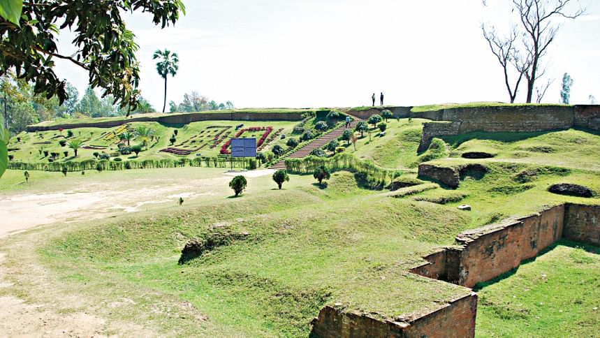
Mahasthangarh: The rampartwalls of Mahasthangarh.

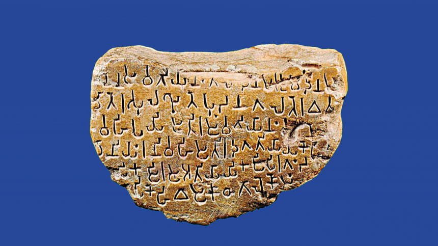
One of the most significant discoveries in Mahasthangarh was a Brahmi inscription from the 3rd century BCE. This inscription confirmed Pundranagara's role as a Mauryan provincial administrative centre.

The inscription is unique because it mentions that at a certain time, a famine occurred in that area due to a natural disaster. In response, the central government issued two orders to the Mahamatra (provincial governor) to start a relief operation for the famine-affected people. It asked the authority to distribute paddy as well as coins called 'Gondok' and 'Kakonik' (punch-marked coins) among the affected. These types of punch-marked coins have been discovered in different places in the country.

After the fall of the Mauryan Empire, the Sunga Empire was established in 185 BC. Many Sunga terracotta plaques have been found in Mahasthangarh during excavations.

Archaeological evidence reveals that the fortified city of Pundranagara developed into a resourceful settlement from the 4th century BCE to the 15th century CE. It served as the provincial capital under the Mauryans, Guptas, Palas, and later Hindu kingdoms.

During the fourth century, the Gupta dynasty was established in a vast part of India and the Pundranagara became part of it and continued to flourish.

In the course of time, it later came under the rule of Raja Sasanka, the first proponent of an independent Bengal. After Sasanka's Hindu kingdom failed, the time of Pala dynasty, who ruled for at least three centuries, started in this region in 750 AD.

After the dynasty decayed, the Sen Dynasty began its rule in the 11th century. The area eventually fell under Muslim rule when Iktiar Uddin Muhammad Bakhtiar Khilji conquered Bengal in 1203 AD.
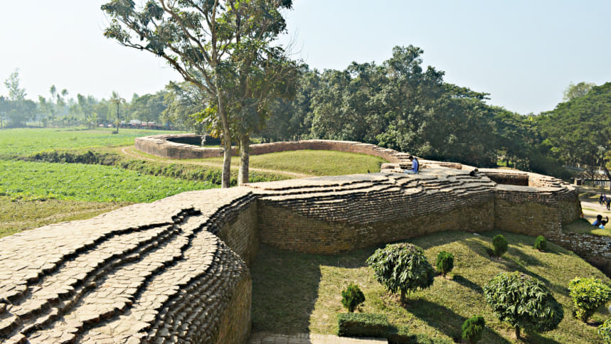
General View of Baragir Vita excavation site in Mahasthangarh

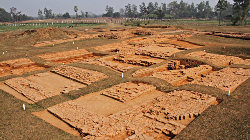
The first archaeological excavations in Mahasthangarh were conducted in 1928-29 at sites such as Bairagir Bhita, Munir Ghon, and Govinda Bhita. These expeditions uncovered cultural sequences from the pre-Mauryan to the Muslim period, revealing structures like houses, roads, wells, and temples. Movable findings include inscribed stones, coins, pottery, terracotta artefacts, beads, and metal objects.
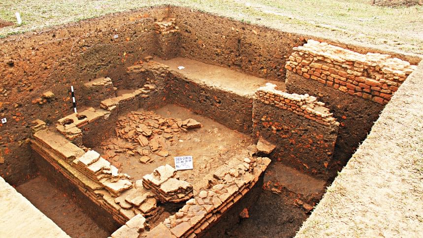
An excavation site south of Bairagir Bhita

Present Condition of the site

Archaeologist Md Mosharraf Hossain in his book Mahasthan: Anecdote of History wrote, "Its ruins lie sprawling over at least 16 square kilometers. Some of the findings from its heyday have been emerging, both accidentally and through excavation, since the late 19th century AD from various points. However, a vast area remains uncovered. Even the movable artefacts are scattered in different museums in the country and abroad."

Tourists, however, face challenges when visiting Mahasthangarh.

Nur Alam, 25, a visitor from Magura Sadar, recently visited Mahasthangarh. However, he was unable to learn much about its history because the museum was closed on Sunday.

Nur Alam told The Daily Star, "I learned about Mahasthangarh from books when I was in school. This place is very beautiful. I came here see the ancient site and know the historical facts of it. Unfortunately, the museum is closed today."
He added, "There are many other archaeological sites around Mahasthangarh, but there are no directions on how to visit those places. If there had been a map at the main entrance of the site, we could have followed it and visited those. Besides, there are no official or private tour guides here to guide us."

Shahidul Islam, a local tourist, recently visited Mahasthangarh with his family from Gaibandha. He told The Daily Star, "I would not have understood that our country's history is so rich if I had not been here. My sons and daughters are also thrilled."

He also felt the need for more detailed descriptions of the site's infrastructure and the people who used to live there. "That could have made the visit more enjoyable and meaningful by providing more insights into this historic place," he added.

Faria Afrin, a private university student who visited the site on 28 November, highlighted the need for dormitory facilities for visitors near the site.

Local van driver Khalilur Rahman said he takes part in the excavation work at the site.

"For 15 years, I have been carrying tourists on my van. The number of tourists is decreasing," he said.
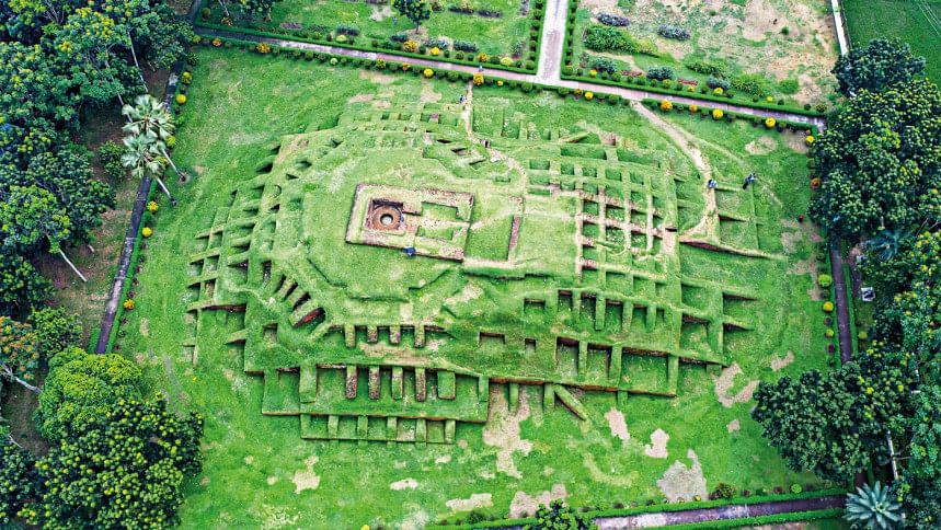
Gokul Medh

Somapura Mahavihara: A Center of Knowledge

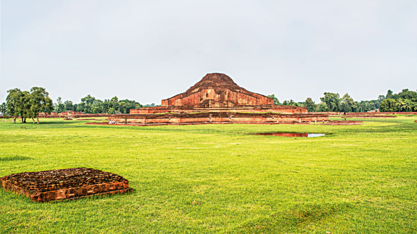
The second king of the Pala dynasty, Dharmapala, constructed the Somapura Mahavihara (modern-day Paharpur Buddhist Monastery) between 770 and 810 CE on 67 acres of land. Initially founded as a Buddhist religious institution, it evolved into a Mahavihara (university), attracting scholars from around the world. The site gained recognition as one of the most important centres for research in religion, education, astronomy, art, and culture during its time.

According to Archaeologists, Somapura Mahavihara bears architectural similarities to Angkor Wat Vihara of Cambodia, Borobudur Temple in Java in Indonesia, Nandadirghi Mahavihara in Wast Bengal's Malda, and Vikramshila Mahavihara in India's Bihar.

The Vihara had 177 residential rooms for monks or students, 92 of which contained altars. At its center stood a high temple built on three levels. The current height of the temple is 21 meters.
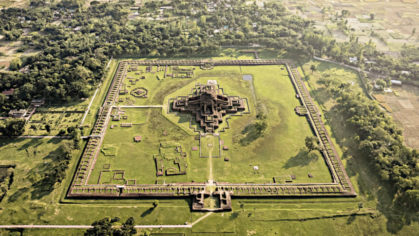
An aerial view of Paharpur Buddhist monastery (8th Century AD), an Unesco World Heritage site.

Satyapir Bhita, a temple of deity Tara, is situated is 365 meters east of Paharpur Vihara. The site is surrounded by 132 offering stupas of different sizes and shapes. The name, Satyapir Bhita, was believed to be associated with place much later in the 16th century.

Paharpur lay buried under a dense jungle till it was rediscovered in the 19th century. British East India Company surveyor Francis Buchanan Hamilton first documented the site. Later, Alexander Cunningham, the Director General of the Archaeological Survey of India, excavated a small part of Vihara's mound in 1879. Subsequent excavations were carried out by Alexander Cunningham, Rakhaldas Bandyopadhyay, GC Chandra Saha, and Kashinath Dixit between 1923 and 1934. During one of the excavations, a seal revealed what it was called back in its heydays.

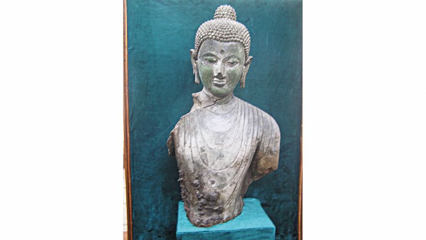
According to the archaeologists, once there was a river flowed by the Vihara. Excavations of Paharpur and Satyapir Bhitar unearthed 50 terracotta tablets of Tara Devi, several images of the deity bronze artefacts, and sandstone statues, many of which are displayed in the Paharpur Archaeological Museum.
A bust of Gautama Buddha made of bronze foundin Paharpur.

Present condition of the site

Today, Paharpur faces challenges such as poor road connectivity and environmental degradation. Visitor Iqbal Mostafa described his visit as enlightening but noted the difficulty of reaching the site. Roads leading to Paharpur are narrow and in poor condition, though efforts are underway to improve infrastructure.

The excavated portions of Paharpur are also deteriorating due to climate change, heavy rainfall, and salinity.

Naheed Sultana, Regional Director(Rangpur, Rajshahi) of the Department of Archaeology (DoA) said, "Earlier we applied chemicals to clean the ancient structures, but now chemicals are prohibited worldwide. Cleaning is now conducted with soft brushes and water to minimize damage."

Due to climate change, the monuments are getting affected by salinity and algae, she said, explaining the blackish hue on the excavated portion.

When asked about the poor road conditions, Md. Rashedul Haque, executive engineer of the Roads and Highway Department, Naogaon, said, "From the Paharpur bazaar, there is a narrow and zigzag road that connects the Vihar. A new 550 meter 34 feet wide road with footpath is being built. Visitors will also have car parking facilities."
A Brahmi Inscription from the Third century BC found in Mahasthangarh.  

Fajlul Karim Arju, a custodian of the Paharpur, said plans are underway to preserve the sites better and make the experience of the visitors more exciting and hassle-free.

"We are making digital content to promote the sites. We are also planning to install giant digital monitors at Paharpur and Mahasthangarh sites so that visitors get enough information about these places," he said.

Comments

ড. ইউনূস

শিগগিরই আয়নাঘর পরিদর্শনে যাব: প্রধান উপদেষ্টা

বৈঠকে কয়েকটি গুমের ঘটনার নৃশংস বর্ণনাও প্রধান উপদেষ্টাকে জানিয়েছেন গুম সংক্রান্ত তদন্ত কমিশন।

২ ঘণ্টা আগে