Landslide fears after Nepal quakes

The Nepal earthquake and its aftershocks have probably triggered many landslides, scientists warn.
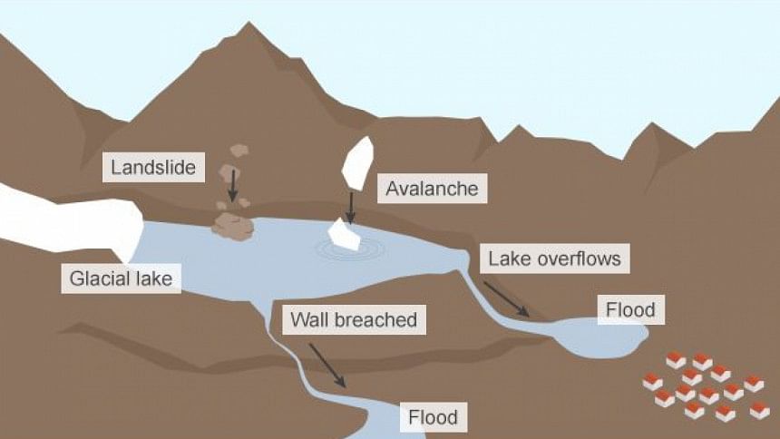
Some could block rivers, causing temporary lakes that could burst out and sweep away settlements and infrastructure downstream.
The mountainous terrain is traversed by hundreds of gushing rivers that contribute up to 70% of the lean season flow of the Ganges in bordering India.
The epicentre of the last quake was a remote mountain area in western Nepal.
But aftershocks and tremors were felt as far as Mount Everest in the east of the country.
Scientists also say the earthquake that triggered avalanches in the Everest region may have destabilised glacial lakes there, which also pose potential threats.
"The steep topography and high relief in the area of the epicentre, and the high intensity of shaking that was felt, mean that thousands of landslides are likely to have been triggered by the earthquake," said Dr Robert Parker, a researcher with Cardiff University's School of Earth and Ocean Science. He studies the occurrence of landslides after earthquakes.
He added: "These landsides could range from a boulder fall to rock avalanches."
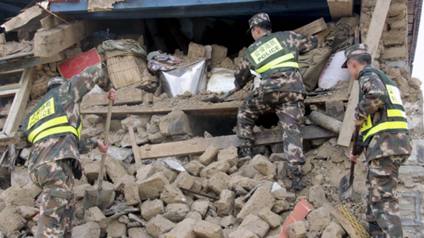
Nepalese officials say they have information of landslides in some areas, including Gorkha district at the epicentre of Saturday's devastating quake, but are yet to get the complete picture.
They say villages in the Langtang region, to the west of Kathmandu, have been buried under landslides.
Villages in the mountainous region are commonly found on steep slopes.

There were initial reports of some rivers partially blocked by mudslides at several points.
Scientists say satellite images have not been very helpful because the region has remained clouded. Clear pictures are yet to emerge.
"Usually what happens in a big earthquake in a mountain zone like this is that the earthquake itself triggers a substantial number of landslides," says Prof Dave Petley, pro-vice chancellor at the University of East Anglia, who has been studying Nepal's landslides for 15 years now.
"It really depends on all sorts of conditions, some of which we really don't understand particularly well, but Nepal is a very landslide-prone country, so we would expect to see a significant impact from landslides in this earthquake."
Experts say there have been several landslides in Tibet across Nepal's border following the earthquake.
China's state media reported that the Chinese government had cancelled all spring season climbing on the north face of Mount Everest.

Nepalese officials said they had no plans to stop expeditions yet.
But scientists say the geological consequences of Saturday's earthquake cannot be ignored.
"Based on past experience of earthquakes in steep, mountainous terrain, like the 2005 Kashmir and 2008 Wenchuan earthquakes, some of these landslides will be large enough to create temporary dams across rivers in the area," explained Dr Parker.
"The lakes created by these dams are particularly hazardous because they can drain without warning, usually within a few days of filling up, due to collapse of the unstable dam material."
Pakistan's scientists say a lake that formed in 2010 after a landslide and which blocked the Hunza River was caused by an earthquake.
The monsoon rains, which will begin in a few weeks' time in the region, will make landslides on earthquake-hit mountains of Nepal even more likely, according to experts.
"What we normally see in the mountain area that has an earthquake is that in the first heavy rainfall after the event, we get a substantial number of landslides," said Prof Petley.
Given that the latest earthquake had caused avalanches in the Everest region, there are fears that the rapidly filling glacial lakes in the area may also have been somehow affected.
Glaciologists say that even if no incident of glacial lake outburst has been detected in the aftermath of the earthquake so far, the danger is far from over. The tremors may have weakened the moraines of these lakes or loosened glaciers hanging above them, storing up problems for the future.

"Everest was not even the zone of highest shaking and so if you had that sort of event there, surely other areas closer to the zone of maximum shaking will have experienced ice and snow avalanches."
The outburst of the Dig Tsho glacial lake near Everest in 1985 was triggered by a large ice and rock avalanche.
The splash into a relatively small lake led to an outburst. The floodwaters swamped a hydroelectric plant and other infrastructure.
The Himalayan region is dotted with glacial lakes and even the smaller ones need watching - especially during earthquakes, the experts say.
There have been around 40 glacial lake outburst events in Nepal, Pakistan, Bhutan and China during the last century, according to the United Nations Environment Programme.

 For all latest news, follow The Daily Star's Google News channel.


Comments