Opinion

Time to develop a reliable flood forecasting model
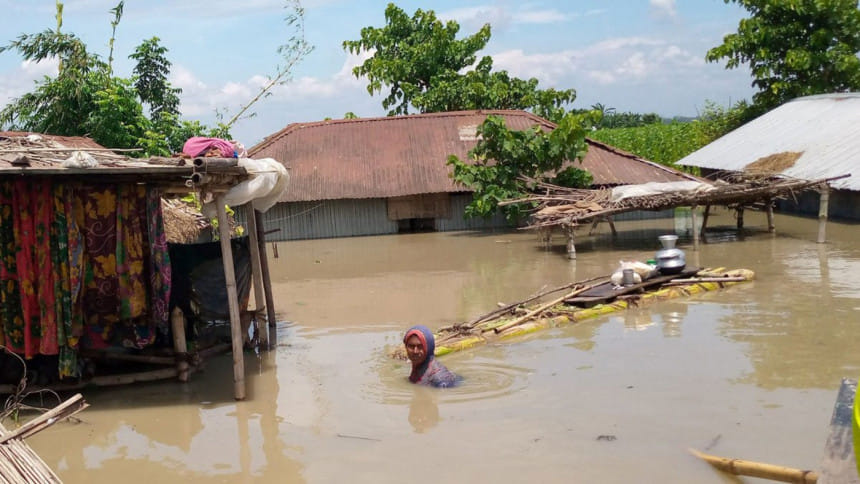
To effectively address flooding disasters in Bangladesh, it is essential to invest in developing a reliable flood forecasting model that will integrate processes, people, and politics. File Photo: Star

Most of Bangladesh is located within the floodplains of three large river systems: the Ganges, Brahmaputra and Meghna (GBM), with over 90 percent of the basin area outside Bangladesh. Flood is thus a natural phenomenon here, and people have been living with floods for centuries. Yet, not all floods are created equal, so to speak, nor all floods lead to a flooding disaster.

Currently, the Flood Forecasting and Warning Center (FFWC) of Bangladesh Water Development Board provides one official five-day deterministic forecast and experimental probabilistic forecasting guidance. The five-day forecasting relies on detailed hydrologic modelling and is resource-intensive. A longer lead-time forecast will help minimise the impact of flooding disasters through better preparation and mitigation efforts.

This year, flood started somewhat earlier than usual. The Brahmaputra water crossed the danger level (DL) on June 28, subsided after a week, and then crossed the DL again on July 13 and continued for 26 days. It inundated over 30 percent of the country. In early August, there was a fear caused by the prediction of several forecasting agencies that a third wave of flood may come in August. Fortunately, it did not materialise. The Brahmaputra did not cross DL in August, and the Ganges and the Meghna did not cross the DL at all this year. Hopefully, the devastation of the flood season is nearly over for 2020.

The question is, how can we have a more reliable flood forecasting model for the future?

The three major rivers—the Brahmaputra at Bahadurabad, the Ganges at Hardinge Bridge, and Meghna at Amilshad—contribute over 80 percent of the water flow into Bangladesh. Given that over 90 percent of the GBM river basin is outside Bangladesh, it is critical to know upstream rainfall conditions, as well as the expected water flow into Bangladesh, to develop an accurate flood forecasting system. For example, rainfall at the farthest part of the Ganges basin may take 20-25 days to reach the Hardinge Bridge, while rainfall in Bihar may take only a few days to arrive at the bridge. A real-time data sharing of rainfall and water flow conditions across three major rivers from upstream countries like India, China, and Nepal can significantly enhance the accuracy of flood forecasting within Bangladesh.

In reality, however, such data sharing is not common. It is not helpful to engage in endless conversations about the power and politics of data sharing. We need to act with the capacity and constraints we have. For example, with the increased availability of satellite data and global model predictions of rainfall, data sharing, although desirable and useful, may become less and less relevant with time. We need to invest in a different type of flood forecasting platform.

Such a flood forecasting platform will recognise the unavailability of data from upstream countries and utilise the large-scale rainfall patterns captured by the satellite and global models to develop a data-driven model. A new forecasting approach, called Requisitely Simple (ReqSim) Flood Forecasting model, has been issuing a 10-day water level forecast for multiple river points in Bangladesh for the 2020 flood season, using easily available satellite data and global model output. The forecasting accuracy of ReqSim has been found to be comparable with or even better than existing models, as demonstrated during 2017 and 2019 flood seasons.

The functional capabilities and demonstrated success of ReqSim can be integrated with the experience and institutional strengths of the FFWC of Bangladesh Water Development Board. The FFWC is currently providing a five-day deterministic forecast while the ReqSim is providing a 10-day forecast. These two complementary activities can provide the basis for an operational flood forecasting model. Such a model will expand the narrow narrative of water crossing the danger level to include other essential attributes of an effective early warning platform for actionable outcomes.

Often, it may not be the type of flood but the timing of flooding that creates disastrous consequences. For example, a flash flood in the Sylhet region in April may cause more damage to crops than a monsoon flood in Sylhet in July. Over the last 35 years, the Brahmaputra at Bahadurabad has crossed danger level a total of 29 times. Yet, not all 29 crossings had similar flooding in northern Bangladesh.

In the summer of 1998, over 60 percent of Bangladesh was inundated as the three major rivers exceeded the danger level almost simultaneously and created one of the most disastrous floods. In 2017, on the other hand, a significant amount of rainfall in the Brahmaputra basin created havoc in the northern region, but the Ganges and the Meghna did not cross the danger level, and the overall impact of the 2017 flood in Bangladesh was not as severe as that of 1998. Of the 30 river points monitored by the FFWC in the Ganges basin last Monday, August 24, water levels were flowing below the danger level at 27 points. Yet, over 30 percent of the country remain inundated. In other words, the crossing of danger level may not be a useful indicator of a flooding disaster.

Information about other natural, societal, and infrastructural factors is essential to forecast whether a flood is likely to create disastrous flooding and to minimise the associated impact. Following the guidelines of the UN Office for Disaster Risk Reduction, an operational flood warning platform needs to include four components: I) risk knowledge, II) monitoring and warning, III) dissemination and communication, and IV) response capability. Just having a high-quality forecasting model is not enough to reduce the impact of flooding. Failures in minimising impacts usually come from the "communication" and "response capability" elements as well as from the lack of public and political awareness of "risk knowledge".

To effectively address flooding disasters in Bangladesh, it is, therefore, essential to invest in developing a reliable flood forecasting model that will integrate processes, people, and politics.


Professor Shafiqul Islam is Director, Water Diplomacy Program, Civil and Environmental Engineering, Fletcher School of Law and Diplomacy at Tufts University, USA.

Comments

সব চুক্তি মেনেই সীমান্তে বেড়া দেওয়া হচ্ছে: ভারতের পররাষ্ট্র মন্ত্রণালয়

ভারতে নিযুক্ত বাংলাদেশের ভারপ্রাপ্ত হাইকমিশনার মো. নূরুল ইসলামকে তলব করে এ কথা জানিয়েছে ভারতের পররাষ্ট্র মন্ত্রণালয়।

১২ ঘণ্টা আগে