Environment
Environment

The water benders of Satkhira
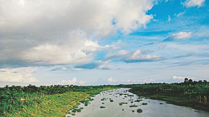
How a community brought a river back to life
Photo: Zahid Amin

The first time I visited Satkhira, the tide country, was as a student of Environmental Science. And I remember returning with pages upon pages of focus group discussions with villagers who were living in homes that had been cut off from nearly everything because of water-logging. They talked of a life constantly battling a disaster.

Almost all these villages were under siege from water-logging, thanks to the 1960s and 70s flood control and drainage provision projects. This was in 2012 and I was visiting the villages in the area as part of a “Disaster Management” course.

Despite their complaints, the locals back then were also hopeful of a new project taken up by the government which promised to completely eradicate water-logging in the area, bring back to life the dying Kabodakh river and elevate and even reclaim land in the lower-lying lands of the river basin (thus effectively creating a means to adapt to climate change). Bangladesh is considered one of the most vulnerable countries to climate change, and Satkhira, it is believed, will be one of the most affected.

Fast-forward to 2018 and the project which was meant to be implemented in 2011-2012 has finally been in operation for around three years now, and is beginning to show results.

Breathing life back into a dying river

The sight was dystopian to say the least—watching huge CAT dredgers with the pristine backdrop of the Kabodakh river in Tala upazila of Satkhira. But the locals were clearly unfazed by this bizarre sight. The Kabodakh river was running dry and dredging, at that time, seemed like the only way out of this crisis.

But drawing from other examples of rivers in Bangladesh, we know that once a river dies from siltation, sporadic dredging is not the answer. You dredge once, the river jumps back to its original state temporarily but the siltation process is continuous and the river gets filled up again.

In the south-west districts of Bangladesh, this problem is more pronounced. That is because these rivers are subject to tidal action. Everyday, twice a day, water from the bay rushes in: this is high tide. With the incoming tide, also comes sediment in high speed. The high tide is followed by ebb tide, this is when the water recedes. This ebb tide, however, happens at a lower velocity, and as the water speed slows down, it leaves back sediment in the riverbed, eventually raising the riverbed and in the process, ending up killing the river completely.

This is essentially what happened to Kabodakh river. Now you might wonder: why, then, did the locals blame flood embankment projects from the 60s for all of this?

For this we need to look back a few decades.

Following severe floods in 1954, the East Pakistan Water and Power Development Authority (EPWAPDA) and present-day Bangladesh Water Development Board worked towards establishing embankments in the area to protect the area from flooding. Under the Coastal Embankment Project (CEP), which started in the late 50s and continued until the early 80s, polders were constructed in the south-west delta to decrease saline intrusion in the flood plains and to increase agricultural production. In the beginning, the project looked promising.
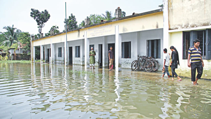
Waterlogging used to be a common problem in these areas prior to implementation of TRM. Photo: courtesy

People could now have three harvests compared to their one harvest before. However, in the late 1980s, the delta started to experience severe problems related to drainage congestion and water logging. This meant agricultural production also went down and some areas became permanently waterlogged, according to a 2007 report by the Asian Development Bank.

This rapid sedimentation is blamed on a lack of upstream flow which helps in flushing out sediment from these rivers. The construction of embankments decreased the volume of water entering the river during high and low tide which then reduced the flow velocity (speed) of the water in these tidal rivers.

Consequently, sediment started settling down in rivers that were essential for draining the polders made under the CEP.

Before the CEP, sedimentation occurred mainly on the low-lying floodplains—that is, the river water would sometimes flood the nearby plains of the river bank and the sediment would settle there. As the water retreated through the river channel during ebb tide—causing relatively high flow velocity—sediment settled on the floodplains instead of the riverbed during dead tide. Because of the presence of the floodplains holding large quantities of water, rivers would drain a large quantity of water, which resulted in a reduced pace of overall sedimentation and maintain the navigability of the river.

But the embankments effectively limited the water flowing into the river from draining into lower lying floodplains. Locals for a few short years were relieved from flooding but the river dynamics were severely affected by this man-made intervention. The silt and sediment brought in by the incoming tide now just settled on the river-bed thus slowly filling it up completely. 

The river-bed continued to get raised compared to the other land areas nearby and as a result, rainwater and floodwater would not drain into the river. Thus began years of water-logging around so many of the upazilas in Satkhira, just around 15 years after the implementation of the CEP.

“I can show you maps of the Satkhira upazila over the 70s, 80s and 90s and you can see it getting bluer and bluer by each decade. You know what that is? That is water-logging. Villages upon villages, schools, agricultural land just under stagnant water that refuses to drain because a project implemented years back thought that by doing so, they would relieve the people of this area from flooding,” says Jahin Shams, programme manager of Uttaran, one of the NGOs responsible for facilitating locals in the tidal river management basin getting compensation.

The Tidal River Management (TRM) project was basically born out of these trying times. Implemented in 2015, the TRM basically aimed at bringing back the Kabodakh river to life.
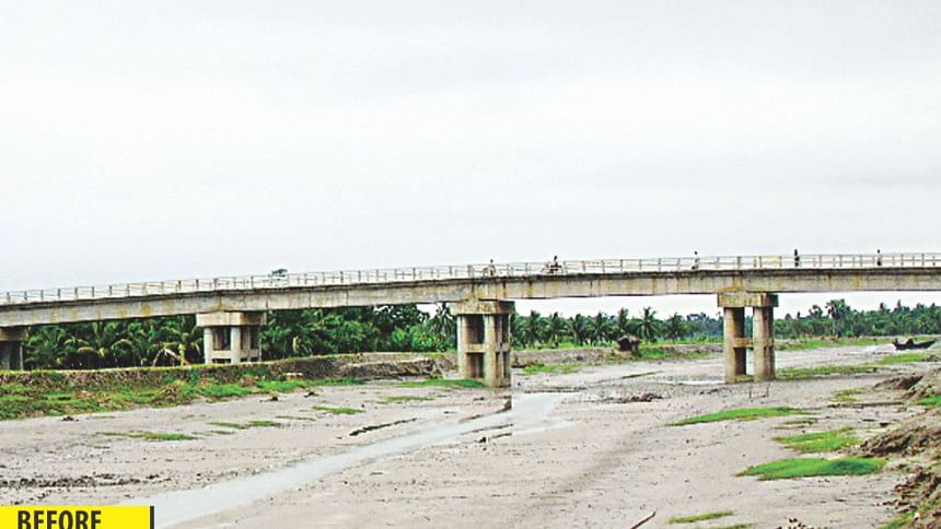
Sediment and silt settled on the riverbed over the years eventually causing it to run dry. Photo: Jahin Shams

At the lower end of the Kabodakh river, where incoming tide is at its highest speed, the Bangladesh government first had to acquire land to broaden a channel that would take the river water towards a basin. By the time the water rich in sediment and silt reaches the basin, the speed at which the river water is flowing reduces significantly and the sediment is dropped at the basin and the rest of the water just drains back.

If you are finding it hard to visualise the entire process then you are among the majority. It took me a whopping six years—through my university years and then some more time while I tried to write this story—to somewhat grasp how the TRM process actually works. But work it does. That is what essentially matters.

Since the TRM project started operation in full swing, the Kabodakh river was dredged as well to remove all the silt that had gathered on the riverbed. The project essentially resulted in silt being collected in a basin, which was a low-lying area where influential people used to do shrimp-farming. The dropping off of silt in the basin raised the land area there. That is one merit of the TRM project—land reclamation. This raising of land area also acts as a defense against climate change. Because these areas are basically at sea-level, a single foot raise in the sea-level would mean these lands are left inundated completely.

The project has also ensured that the Kabodakh river is back to life finally. The water has returned to the river and as a result it can now drain rain water and any rise in water levels does not mean eventual water-logging of nearby villages. Because the river can now hold water, both rain and flood water can drain back into the river. This is the second and most important merit of this project—no more water-logging in the villages in and around the Kabodakh river basin. Since the project was implemented in 2015-16, incidents of waterlogging have been almost completely eradicated.

“Even in 2017, when the entire country experienced flooding on a massive scale, the villages in Tala upazila and other upazilas of the Kabodakh basin were not affected,” says Jahin Shams. He also believes that the project has ensured that the silt and sediment has someplace where it can be dropped off by virtue of tidal action in the river. And this is a more or less permanent solution to the crisis. The TRM also means that there is no more need for regular dredging of the river.

But no project can be hundred percent free of demerits.

The Kabodakh River under the setting sun is a far cry from the dry riverbed it once was. Photo: Jahin Shams

“I did not get any compensation, neither was any measure taken to rehabilitate us. My son had to go away to another area to manage a job. We did not own any land in this area but worked off of the land, working on shrimp farms here, but that is now gone and because we do not have any legal claim to the land, we are not eligible for compensation,” says Hajera Begum, a 60-year old resident who lives at the mouth of the TRM basin area.

This should not come as a surprise because, according to Uttaran, no budget was allocated by the Bangladesh Water Development Board to rehabilitate those who are not legal land owners in the area but who were affected by the connecting channel to Pakhimara Beel in Kabodakh basin.

The demerit of TRM is not in the science behind the process, but in the implementation of it. People whose land had to be acquired for broadening the channel of the TRM project are the ones who have been negatively impacted by the project. These people did not get their due compensation. Some 2,079 families who live around the lower end of the Kabodakh river are among those affected.

But this can be duly addressed as well just by simplifying the process of getting compensation. These are ultra-poor people and many of them do not have the right legal documents to be eligible for compensation,” says Shams.

However, Uttaran, the organisation responsible for ensuring the compensation reaches the right people are working to address this, by acquiring documents and making runs to the Satkhira land office, he opines. 

Hajera is not entirely against the TRM though. “The newly reclaimed land where the silt was deposited has seen a bumper harvest of rice this year. People did not even need to use fertiliser,” says Hajera.

The Kabodakh river is beautiful under the setting sun. We sit and watch as river dolphins come to play with the changing of tide. The dolphins have come back to the river after nearly a few decades and it is easy to see why there are so many people who are demanding for the TRM to be implemented on their dying rivers as well.

Comments