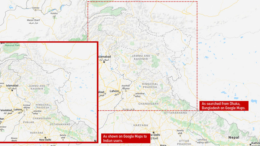
‘Google Maps redraws borders depending on who’s looking’

On Google Maps, borders are dynamic. In this case what we mean is on Google, world borders appear different, depending on where you are viewing them from.
Google's corporate mission is "to organise the world's information," but the organisation, according to Washington Post, also bends the information to its will.
From Argentina to the United Kingdom to Iran, depending on where you are viewing from, the borders shift and alter. That's because Google—and other online mapmakers—simply change them.
One of the most glaring examples of 'moving borders' can be observed if you are viewing Google Maps from either India and Pakistan.
Both sides claim the Himalayan outpost as their own, but if you look from India, you might be fooled into thinking the dispute is all but settled: The borders on Google's online maps display Kashmir as fully under Indian control.
Elsewhere, users see the region's snaking outlines as a dotted line, acknowledging the dispute.
Washington Post further said Google's decision-making on Maps is "often shrouded in secrecy, even to some of those who work to shape its digital atlases every day."
It is influenced not just by history and local laws, but also the shifting whims of diplomats, policymakers and its own executives, say people familiar with the matter, who asked not to be identified because they weren't authorised to discuss internal processes, the report added.

 For all latest news, follow The Daily Star's Google News channel.


Comments