Natural disaster

1.5 crore more at flood risk

Rising human activity in floodplains putting increasing number of people under submergence threat
flood crisis

"Embankments have been constructed on around 75 percent of rivers of the country. The normal functioning of rivers has been hampered due to human settlements and infrastructural developments in the floodplains of the rivers."

— AKM Saiful Islam Institute of Water Modelling and Management, Buet

In less than two decades, the number of people exposed to flood risks rose by 1.5 crore, around nine percent of the country's population, due to human settlements and infrastructural developments in floodplains, says a study.

The study also found that within the 2km river buffer locations, forests shrunk by 91.98 percent, grassland 6.02 and barren areas by 27.92 percent while built-up areas have increased by 11.06 percent over the period.

On the other hand, the areas of human settlements and infrastructural developments have expanded to 778.74 sq km from 701.19 sq km within that buffer jones across the country. 
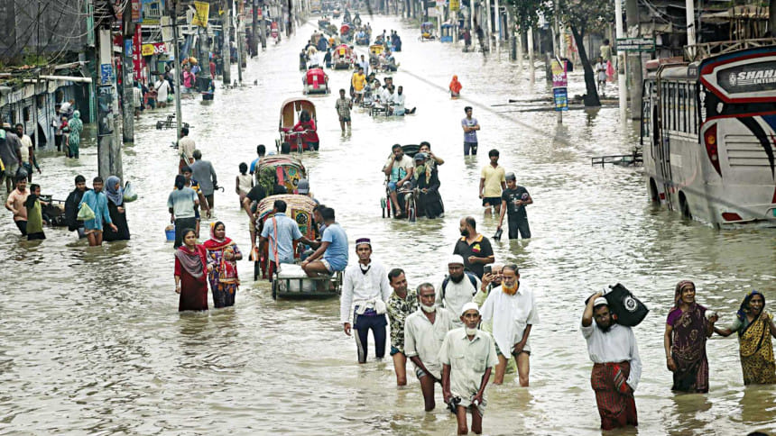
The at-risk population has been increasing since the start of the century but there has seen a sharp rise since 2014, finds the study titled "Dynamics of human presence and flood-exposure risk in close proximity to Bangladesh's river network: an evaluation with multitemporal satellite imagery."

There were around 7.2 crore people living within the 2km river floodplains in 2000. It has risen to 8.7 crore in 2018, it found.

"An increase in human activity in river basins and floodplains is putting more people at risk of flood than ever before," it observes.

The study was published in Geocarto International, a multi-disciplinary journal of remote sensing and Geographic Information Systems (GIS), in late June this year.

Researchers and experts said encroachment of riverbanks and floodplains by individuals and organisations is rampant in some areas and should be stopped immediately to avoid a dire situation in the coming days.

"Embankments have been constructed on around 75 percent of rivers of the country. The normal functioning of rivers has been hampered due to human settlement and infrastructural development in the floodplains of the rivers. So, when the rivers receive a huge amount of water, it takes time for the water level to recede," Prof AKM Saiful Islam of Institute of Water Modelling and Management at Buet told The Daily Star yesterday.

Referring to the study, he said the way the floodplains have been encroached upon or intervened is really worrisome and should be stopped immediately.

"The rivers should be connected with their branches. Rivers should be dredged and their floodplain areas must be protected," he suggested.

Researchers of Pennsylvania State University, Curtin University and the University of Chattogram jointly conducted the study based on satellite images of Nasa taken between 2000 and 2018.

They analysed multitemporal images to examine the spatial distribution and change in nighttime lights (NTL) to identify in which floodplains human settlements and infrastructural developments took place in 18 years.

The satellite images were from two times a day -- 7:00pm to 8:00pm and 2:pm to 3:00pm -- of the entire study period.

Ashraf Dewan, an author of the study and also a professor at Curtin University in Australia, said since the late 1990s, NTL satellite imagery has been used as a proxy for a number of socio-economic parameters, including urbanisation, economic activity, and population.

"Time series analysis of NTL data is especially valuable for detecting, estimating, and monitoring socioeconomic dynamics in countries where reliable official statistics may be lacking," he said.

The study found that between 2000 and 2018, expanding urban across Dhaka and Chattogram districts experienced the highest level of increase in NTL.

Districts that experienced the highest increase in night illumination within 2km river buffer locations in those years are Naogaon, Dinajpur, Mymensingh, Tangail, Sunamganj, Sylhet, and Chattogram.

It found that Dhaka had the most flood-exposure risk for its population living in close proximity to rivers, followed by Chattogram, Khulna, and Sylhet districts.

The researchers found that nighttime illumination increased by around 66 percent over the years since 2000 in the Sylhet region, which saw devastating floods recently. 

What is the impact of this, researcher Arif Masrur of Pennsylvania State University said, "The rise in nighttime light intensity clearly indicates an increased human activity and built-up areas across the Sylhet haor region."

Unplanned development of infrastructures like road networks and buildings in areas near rivers can block rainwater discharge. This can lead to a large-scale submergence -- that's what has been seen in Sylhet region, he added.

Naogaon was the only northern district to be included in the top 20 districts where people near rivers were exposed to floods, followed by the districts in central, north-eastern, and eastern Bangladesh.

Additionally, the southern districts located to the south of the Ganges river have formed a cluster of flood-prone areas with relatively higher risk. Specifically, Khulna district was among the highest-level flood-exposure risk areas, followed by Bagerhat, Satkhira, and Barishal.

Prof Mashfiqus Salehin of Institute of Water and Flood Management (IWFM) at Buet said encroachment of floodplains intensifies the flooding and hampers the natural functioning of rivers.

"By any means, the connectivity between rivers and floodplains should be restored to ensure the normal functioning of a river and to reduce the flood-related damages," he said.

Comments

স্বাধীনতাবিরোধীদের চক্রান্ত প্রতিহতে ঐক্যবদ্ধ হওয়ায় আহ্বান প্রধান উপদেষ্টার

শহীদ বুদ্ধিজীবী দিবসে সবাইকে ঐক্যবদ্ধ হয়ে স্বাধীনতাবিরোধী অপশক্তির যে কোনো চক্রান্ত-ষড়যন্ত্র প্রতিহত করে নিজ নিজ অবস্থান থেকে দায়িত্ব পালনের আহ্বান জানিয়েছেন অন্তর্বর্তী সরকারের প্রধান উপদেষ্টা ড....

৭ ঘণ্টা আগে