Why tidal surges were so high

Southern rivers in Bangladesh were already swelling with waters on May 23 due to the full moon's gravitational dance with the Earth.
Then, three days later, came Cyclone Remal with strong winds and heavy rains.
The arrival of two forces in a deadly coincidence upended coastal lives in the south, laying bare the communities' vulnerabilities to climate change.
The cyclone also left behind an arc of devastation across a region home to about 35 million people, but the worst peril stemmed from tidal surges.
Cyclones are a familiar threat to coastal residents. One of them is Mohammad Masum Hossain. He and his family live near water in Pirojpur's Kowkhali upazila, a marshy area known for meandering rivers and creeks.
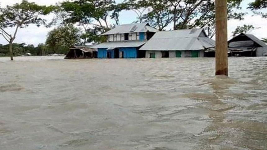
But the afternoon of May 26 brought an unusual nightmare: the rivers burst their banks, sending a deluge of water over the roads into the neighbourhoods. Minutes later, the family's yard disappeared under water.
Masum hoped and prayed that the water would stop climbing and save the house as it was built on higher ground. He was wrong. After dark, water surged further, deluging the house and forcing its dwellers to move household equipment into their beds.
Other coastal residents have similar tales.
"I have seen a lot of floods and cyclones. But I have never seen the water level this high," said 65-year-old Siddiqui Sheikh of Pirojpur Sadar upazila's Bhaijhora village.
Another villager, Md Hasan Sheikh, said, "Not a single house in our area is spared. Most people sought shelter inside the nearby buildings built on higher ground."
Talking to this newspaper, Biswajit Nath, a professor of Geography and Environmental Studies at the University of Chittagong, said, "We misjudged this cyclone and its impact. Many things coincide with cyclones.
"Tides were higher when the moon was full. The full moon, or the flower moon, as it is known, was observed on May 23 when the earth, the sun and the moon were all in the same alignment.
"These astronomical tides have triggered this huge tidal surge during the cyclonic time. It continues in the Bay of Bengal and will continue for the next two days," he said.
There's another culprit -- the ocean surface temperature that has increased by about 2 degrees Celsius since 2020 when Cyclone Amphan caused widespread damage in India and Bangladesh. Scientists observed that the ocean surface temperature was 29.5 degrees Celsius during Cyclone Amphan, compared with 31-32 degrees Celsius in the northern Bay of Bengal now.
Disaster experts tend to conclude every cyclone or storm is unique though patterns within the atmosphere may look similar. Cyclone Remal also stood out by bringing more ominous and lengthy downpours as the atmosphere was warming.
"And Bangladesh is likely to face more cyclones in future because of the warming nature of the ocean and we have observed a two-degree temperature rise in the Bay of Bengal since 2020," Nath said.
Cyclone Remal turned into a depression on Monday morning. The deep depression reached Sylhet on Tuesday afternoon and headed to the Indian state of Assam yesterday evening, leaving the Bangladesh territory.
"The effects of depression lingered for 34 hours. During the whole period, it caused high-impact rainfall across the country," said Abul Kalam Mallik, a meteorologist at Bangladesh Meteorological Department.
Earlier, Cyclone Fani spent 39 hours after making landfall in 2019, Amphan 30 hours in 2020, and Aila 24 hours in 2009.
Before that, a severe cyclone in 2002 and another very severe cyclone in 2000 lasted 24 hours in Bangladesh, according to the weather office.
Citing research titled "Slower decay of landfalling hurricanes in a warming world" conducted by Lin Li and Pinaki Chakrabarty, Mallik said, previous cyclones used to lose 75 percent of their energy after making landfall. Now, cyclones lose barely 50 percent of their energy due to a rise in land surface temperature.
"The cyclones coming to land with extra energy have more gusts and rains and more damage," said Mallik.
Nature, a scientific journal, published a related research conducted by James Kossin in 2018. Kossin found that, worldwide, hurricane translational speeds have slowed down by an average of 10 percent.
Experts say the slowdown effect gets worse when hurricanes reach land, allowing more time for precipitation to fall over a given area. This is one of the primary factors for waterlogging and flooding.

 For all latest news, follow The Daily Star's Google News channel.


Comments