The gaps in DAP: How to avoid urban flooding in Dhaka

The Detailed Area Plan (DAP) 2016-2035, developed by Rajdhani Unnayan Kartripakkha (Rajuk) for the planned urbanisation of Dhaka metropolitan area, has created an opportunity for our capital city to be contemporary and hospitable. The plan puts emphasis on several key areas, such as area-based population density patterns, transit-based as well as block-based development, criteria for civic amenities, hawker management guidelines, inclusion of new and neglected areas as well as land readjustment and redevelopment, conservation of heritage and its geomorphology, etc. These initiatives do deserve applause, but there are certain issues that require rethinking.
A thorough study of the DAP makes it evident that the regulations that it recommends can initiate a spree of development in sensitive areas such as the floodplains and agricultural lands surrounding central Dhaka, posing a serious threat of urban flooding. The new DAP conditionally allows construction of a wide array of infrastructure in these flood flow regions – an idea that not only violates the 2000 law on open spaces, parks and natural water reservoirs, but is also against court orders and public interest.
Out of the 1,528 square kilometres of Dhaka Metropolitan Area (under the jurisdiction of DAP-Rajuk), 1,008 square kilometres is floodplain area, and the rest is flood-free. So, floodplains make up about 66 percent of the greater Dhaka metropolitan area. This area is divided into two zones in the DAP: flood flow, which is 25 percent of the entire DAP area, and general floodplain, which is about 41 percent of the DAP area. The general floodplains have been given conditional land development options. The flood flow area is further divided into main flood flow and general flood flow, with the general flood flow area comprising about 12 percent of the DAP area. This way, 80 percent of the total identified floodplain areas – which is more than half of Dhaka metropolitan – has been brought under conditional land development by means of categorisation of these areas. Only 12 percent has been identified as the main flood flow area, where land development has been prohibited.
DAP also provides conditional construction rights in 28.86 percent of the area identified as agricultural land, allowing the construction of eco-resorts, bungalows, villas, single-family homes, government schools, and other structures. There is also scope for building – conditionally – multi-family units, hospitals, waste management centres and transfer stations, incinerators, dairy and poultry farms, mills, etc. Conditional as they are, such provisions can lead to a spree of construction on floodplains by commercial entities. These loopholes are likely to lead to the destruction of agricultural lands.
It must be mentioned that in areas such as the northern part of Keraniganj, Savar and the vast low-lying lands in Gazipur, many different types of crops are grown. These areas are a source of vegetables for Dhaka. Also, a large amount of paddy is produced in these areas during Boro season. If, as per DAP proposal, these lands are used for construction, Dhaka will be cut off from a major source of food and agricultural items. Such options will only cater to the interests of the so-called housing and other business entities, not the general public.

Dhaka, a city and the central hub of Bangladesh, already suffers from urban flooding, waterlogging, and a significant drop in groundwater levels. Providing scope for construction and development in flood flow areas and agricultural lands surrounding the metropolitan will make the situation even worse. If these options are not reconsidered, chances are Dhaka might see catastrophic floods in the coming years – much like what we saw in Sylhet earlier this year.
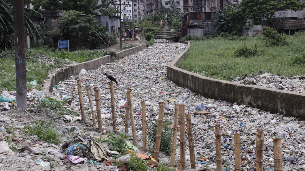
The DAP proposal to establish a "Blue Network" comprising waterways is admirable. But simply laying waterways and replacing culverts with bridges will not help. In order to protect them, Dhaka's canals have to be revived first through comprehensive restoration. The proposal of the urban life line in DAP is also commendable and appropriate. In parallel to the establishment of urban life lines and the restoration of canals, special attention must be ensured for the establishment of necessary connections among them. However, the DAP has not included a list of the 54 canals (currently reduced to 26) identified by the River Task Force of the National River Conservation Commission. Therefore, a clear proposal with a responsible implementation authority is necessary to save these canals on a priority basis, with a precise list and implementation plan, to establish a true Blue Network.
The DAP maps out a pathway to achieve a liveable Dhaka for all. Such a city must have an intertwined network of natural blue and green. In order to establish this network, it is necessary to revive, restore and conserve its water bodies. The provisions for construction in the sensitive lowlands pose a serious threat to the future of this megacity. Rajuk should therefore evaluate and adjust DAP's proposals by assessing their possible impacts. One of the important components of implementing the DAP is collaborative nurturing, and it is via this that a good, balanced, transparent, elegant, and universally acceptable master plan should be ensured.
Iqbal Habib is joint secretary at Bangladesh Poribesh Andolon (Bapa).
Mubasshar Hussain is president of the Institute of Architects, Bangladesh (IAB).
Syeda Rizwana Hasan is chief executive of Bangladesh Environmental Lawyers Association (BELA).
Kazi Golam Nasir is former chief architect at the Department of Architecture of the Ministry of Housing and Public Works.


 For all latest news, follow The Daily Star's Google News channel.


Comments