Views
Explainer

What are atmospheric rivers?
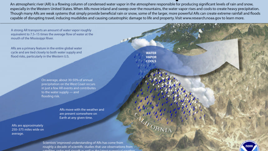
An old weather phenomenon with a new twist
atmospheric rivers
Infographic: NOAA

If we ask people to name the world's longest river, the answer from most will probably be the Amazon, the Nile, or the Mississippi. Yes, these are amongst the longest rivers on the surface of the Earth. But if you think that rivers only exist on land, think again. Holding an entire river of water in the form of moisture, they also exist in the atmosphere and are known as atmospheric rivers (AR).

Appearing as a trail of wispy clouds, ARs are long "meandering plumes" of water vapour in the atmosphere nearly 2000 kilometres long and about 800 kilometres wide. The flow of water in an AR can be as much as two and a half times the flow of water that discharges from the Amazon River, or according to the National Oceanic and Atmospheric Administration (NOAA), 15 times the volume of the Mississippi River.

Atmospheric rivers originate over oceans in the tropical regions. Warm temperatures there cause ocean water to evaporate and rise into the atmosphere. Strong winds carry the water vapour through the atmosphere to higher latitudes. As ARs move over land, the water vapour rises up farther into the atmosphere, generating rain and snowfall. On average, there are about five to 10 ARs moving through the atmosphere at any one time. Each one, depending on the amount of moisture it contains, lasts from a few to several days before weakening and falling apart.

Climate scientists distinguish ARs from other kinds of storms by the amount of water vapour they carry and how long they last in a particular region. They use these characteristics to form the basis for a five-point ranking of ARs – from "weak" to "moderate" to "strong" to "extreme" to "exceptional" (AR-1 through AR-5). The ranking helps communities understand whether an AR will bring benefit or cause chaos. Obviously, weaker ones (AR-1) produce beneficial rain and help mitigate droughts, while larger ones (AR-4 and AR-5) result in torrential rainfall, heavy snowfall, menacing floods and destructive mudslides. In 2022, an AR-5 contributed to disastrous flooding in Pakistan.

Extreme ARs are no longer a rare phenomenon, as they were several decades earlier. They are more likely to materialise during strong El Niño years, which should be of concern because the National Oceanic and Atmospheric Administration (NOAA) has recently forecasted that an El Niño condition will almost certainly develop in the coming months. Exceptional ARs are rare and less probable to make landfall, but when they do, they are unlikely to maintain their strength for long and penetrate farther inland. Their impacts, albeit pernicious, are felt mostly in coastal areas.

One extreme or exceptional AR can be enough to flood homes and down power lines, as well as wash away hillsides and highways. And when several ARs sweep ashore in a matter of days or weeks, the potential damage is multiplied. As an example, in 2021, an exceptional AR dumped a month's worth of rain on British Columbia in two days, prompting cataclysmic floods, deadly landslides and debris flows, thereby destroying a large number of communities.

How is climate change affecting atmospheric rivers? In a warmer world, the atmosphere above the ocean will contain more water vapour. Consequently, ARs will transport greater amounts of water vapour than they will usually do. Hence, when they will make landfall, they will release a greater amount of precipitation, potentially causing greater damage.

A well-known AR, colloquially called the "Pineapple Express," picks up warm, moist air from the Pacific Ocean near Hawaii. When it hits land in the Western United States and Canada, it can cause unending rain and snow. In 2019, the Pineapple Express wreaked havoc in California by triggering mudslides that sent homes sliding downhill.

In a matter of months earlier this year, California was battered by an onslaught of 31 AR-4 storms. Instead of the much-needed rainfall residents and officials hoped could end a nightmarish fire season, revitalise dried landscapes and end the drought, the state got a deluge – drenching precipitation, record snowfall and catastrophic flooding. 

Besides causing death, staggering devastation and destruction, ARs can be quite useful too. Since lack of rain can prolong droughts and wildfire season, many drought-stricken and wildfire prone regions, such as Australia and west coast of America, welcome ARs, the weaker ones though. Additionally, the precipitation and snow they generate contribute to annual freshwater supplies.

We should not confuse ARs with hurricanes or cyclones, although all three are formed over the oceans, and can cause extreme precipitation and high winds. However, the similarities end there. Powerful hurricanes and cyclones are formed in the tropics. Because they need warm ocean waters to survive, these storms weaken very quickly once they make landfall. Nevertheless, in terms of impacts, hurricanes and cyclones generally have much stronger winds and damaging storm surges. The damage from ARs, on the other hand, occur in the form of flooding and landslides.

How is climate change affecting atmospheric rivers? In a warmer world, the atmosphere above the ocean will contain more water vapour. Consequently, ARs will transport greater amounts of water vapour than they will usually do. Hence, when they will make landfall, they will release a greater amount of precipitation, potentially causing greater damage. Warmer temperatures also mean that precipitation due to ARs will increasingly fall as rain instead of snow, even in mountainous regions, leading to greater risk of floods.

Furthermore, a 2018 NASA-led study shows that climate change is expected to intensify ARs across most of the globe by the end of this century. The study also projects ARs will be significantly longer and wider than the ones we observe today, initiating more frequent AR conditions in affected areas. Another consequence of climate change is that ARs will possibly increase in frequency, with variation between different regions.

In conclusion, atmospheric rivers can be both beneficial and calamitous. They are beneficial when they provide water to fill reservoirs, end droughts and build snowpack. They are calamitous when they generate so much precipitation over a short period of time that they cause flooding and landslides. They are therefore like Prometheus who offers the blessings and curses of fire at the same time.

Dr Quamrul Haider is a Professor of Physics at Fordham University, New York, USA.

Comments

Explainer

What are atmospheric rivers?

An old weather phenomenon with a new twist
atmospheric rivers
Infographic: NOAA

If we ask people to name the world's longest river, the answer from most will probably be the Amazon, the Nile, or the Mississippi. Yes, these are amongst the longest rivers on the surface of the Earth. But if you think that rivers only exist on land, think again. Holding an entire river of water in the form of moisture, they also exist in the atmosphere and are known as atmospheric rivers (AR).

Appearing as a trail of wispy clouds, ARs are long "meandering plumes" of water vapour in the atmosphere nearly 2000 kilometres long and about 800 kilometres wide. The flow of water in an AR can be as much as two and a half times the flow of water that discharges from the Amazon River, or according to the National Oceanic and Atmospheric Administration (NOAA), 15 times the volume of the Mississippi River.

Atmospheric rivers originate over oceans in the tropical regions. Warm temperatures there cause ocean water to evaporate and rise into the atmosphere. Strong winds carry the water vapour through the atmosphere to higher latitudes. As ARs move over land, the water vapour rises up farther into the atmosphere, generating rain and snowfall. On average, there are about five to 10 ARs moving through the atmosphere at any one time. Each one, depending on the amount of moisture it contains, lasts from a few to several days before weakening and falling apart.

Climate scientists distinguish ARs from other kinds of storms by the amount of water vapour they carry and how long they last in a particular region. They use these characteristics to form the basis for a five-point ranking of ARs – from "weak" to "moderate" to "strong" to "extreme" to "exceptional" (AR-1 through AR-5). The ranking helps communities understand whether an AR will bring benefit or cause chaos. Obviously, weaker ones (AR-1) produce beneficial rain and help mitigate droughts, while larger ones (AR-4 and AR-5) result in torrential rainfall, heavy snowfall, menacing floods and destructive mudslides. In 2022, an AR-5 contributed to disastrous flooding in Pakistan.

Extreme ARs are no longer a rare phenomenon, as they were several decades earlier. They are more likely to materialise during strong El Niño years, which should be of concern because the National Oceanic and Atmospheric Administration (NOAA) has recently forecasted that an El Niño condition will almost certainly develop in the coming months. Exceptional ARs are rare and less probable to make landfall, but when they do, they are unlikely to maintain their strength for long and penetrate farther inland. Their impacts, albeit pernicious, are felt mostly in coastal areas.

One extreme or exceptional AR can be enough to flood homes and down power lines, as well as wash away hillsides and highways. And when several ARs sweep ashore in a matter of days or weeks, the potential damage is multiplied. As an example, in 2021, an exceptional AR dumped a month's worth of rain on British Columbia in two days, prompting cataclysmic floods, deadly landslides and debris flows, thereby destroying a large number of communities.

How is climate change affecting atmospheric rivers? In a warmer world, the atmosphere above the ocean will contain more water vapour. Consequently, ARs will transport greater amounts of water vapour than they will usually do. Hence, when they will make landfall, they will release a greater amount of precipitation, potentially causing greater damage.

A well-known AR, colloquially called the "Pineapple Express," picks up warm, moist air from the Pacific Ocean near Hawaii. When it hits land in the Western United States and Canada, it can cause unending rain and snow. In 2019, the Pineapple Express wreaked havoc in California by triggering mudslides that sent homes sliding downhill.

In a matter of months earlier this year, California was battered by an onslaught of 31 AR-4 storms. Instead of the much-needed rainfall residents and officials hoped could end a nightmarish fire season, revitalise dried landscapes and end the drought, the state got a deluge – drenching precipitation, record snowfall and catastrophic flooding. 

Besides causing death, staggering devastation and destruction, ARs can be quite useful too. Since lack of rain can prolong droughts and wildfire season, many drought-stricken and wildfire prone regions, such as Australia and west coast of America, welcome ARs, the weaker ones though. Additionally, the precipitation and snow they generate contribute to annual freshwater supplies.

We should not confuse ARs with hurricanes or cyclones, although all three are formed over the oceans, and can cause extreme precipitation and high winds. However, the similarities end there. Powerful hurricanes and cyclones are formed in the tropics. Because they need warm ocean waters to survive, these storms weaken very quickly once they make landfall. Nevertheless, in terms of impacts, hurricanes and cyclones generally have much stronger winds and damaging storm surges. The damage from ARs, on the other hand, occur in the form of flooding and landslides.

How is climate change affecting atmospheric rivers? In a warmer world, the atmosphere above the ocean will contain more water vapour. Consequently, ARs will transport greater amounts of water vapour than they will usually do. Hence, when they will make landfall, they will release a greater amount of precipitation, potentially causing greater damage. Warmer temperatures also mean that precipitation due to ARs will increasingly fall as rain instead of snow, even in mountainous regions, leading to greater risk of floods.

Furthermore, a 2018 NASA-led study shows that climate change is expected to intensify ARs across most of the globe by the end of this century. The study also projects ARs will be significantly longer and wider than the ones we observe today, initiating more frequent AR conditions in affected areas. Another consequence of climate change is that ARs will possibly increase in frequency, with variation between different regions.

In conclusion, atmospheric rivers can be both beneficial and calamitous. They are beneficial when they provide water to fill reservoirs, end droughts and build snowpack. They are calamitous when they generate so much precipitation over a short period of time that they cause flooding and landslides. They are therefore like Prometheus who offers the blessings and curses of fire at the same time.

Dr Quamrul Haider is a Professor of Physics at Fordham University, New York, USA.

Comments

পুঁজিবাজার

সমালোচনার মুখে ৯ পণ্য-সেবায় ভ্যাট-শুল্ক কমাল এনবিআর

প্রায় ১০০টি পণ্য ও সেবায় ভ্যাট বাড়ানোর দুই সপ্তাহের মধ্যে সাধারণ মানুষ ও ব্যবসায়ীদের সমালোচনা এবং প্রতিবাদের মুখে এই সিদ্ধান্তে এসেছে এনবিআর।

১ ঘণ্টা আগে