Views

Why Western approaches can't prevent river erosion in Bangladesh
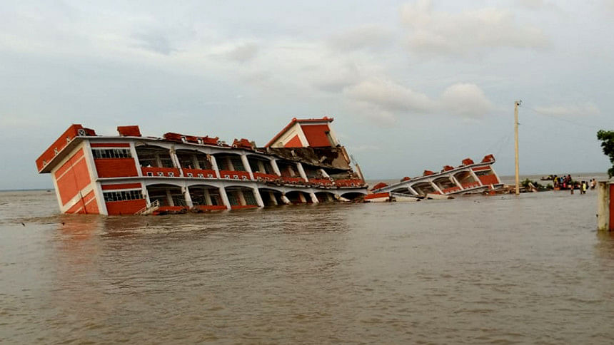
This newly constructed school building in Madaripur's Shibchar upazila was able to withstand the force of the Padma's current for two weeks before it collapsed into the river, thanks to the erosion. FILE PHOTO: STAR

With each passing year, Bangladesh's land gradually crumbles and washes away due to river erosion. According to researchers, the total amount of land eroded by the Ganges, Jamuna, Padma, and Lower Meghna rivers between 1973 and 2014 was 182,000 hectares, while the accretion amounted to 80,000 hectares, signifying a net erosion of 102,000 hectares – exceeding accretion by 2.3 times. River erosion is devastating for the people who lose their homesteads and lands for cultivation. While a fire leaves some traces and allows people to rebuild in the same place, erosion represents complete annihilation that leaves no trace and no place to rebuild. It literally makes people destitute.

Over time, river erosion has also become costlier for both the affected people and the nation as a whole. With economic development, there are now more capital construction (buildings and structures), both public and private, in the rural areas. All this capital gets washed away by river erosion.

It is true that eroded banks add to the sediment that the rivers ultimately carry to the estuary and, as a result, more land is rising above the sea level. However, this gain in the estuary cannot compensate for the loss suffered inside the country. It takes decades and a lot of new investment to develop the newly risen land to make it comparable in value to the land lost inside the country. Hence, mitigation of river erosion is an important task from both humanitarian and economic viewpoints. The question is, how to achieve this goal?

To control erosion, the authorities so far have used Western methods that focus on construction of hard structures, such as groynes, spurs, concrete revetments, hardpoints, etc. Also, following the Western advice, the authorities adopted the Cordon approach to rivers and constructed embankments to cordon off floodplains from rivers. Unfortunately, neither the embankments nor the hard structures have proven to be effective in Bangladesh. In fact, they have proven to be a deadly combination instead.
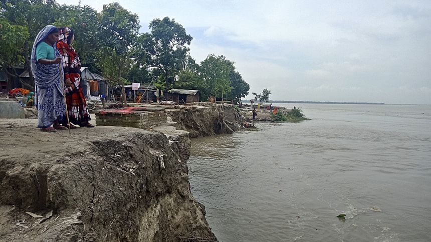
For years, people in Bangladesh have been living with the devastating effects of river erosion, losing their homes and croplands. This photo was taken in Sirajganj. PHOTO: STAR

The experience of the Jamuna River provides a good example. The Cordon approach was applied to this river through the construction of the Brahmaputra Right Hand Embankment (BRHE) in the 1960s to cordon off the right-hand-side floodplains from the river. This project was financed largely by the World Bank. Also, numerous hard structures were built to prevent the right-side bank from erosion. Yet, the river eroded its right-side bank and moved westwards by more than 1.5 kilometres on average. The BRHE had to be continually retired and moved back, by more than nine times at some places. As a result, currently only 41 kilometres of the original 180-kilometre embankment remain standing. In many places, the embankment has virtually ceased to exist. The experience with other rivers has been in essence similar to that with the Jamuna River.

Figure: Erosion and accretion by major rivers of Bangladesh (1973-2014)
Figure: Annual volume of flows of the Ganges, Brahmaputra, and Rhine rivers (in cubic km) Source: Author, based on data from Dai, Aiguo and Kevin E. Trenberth (2002)

The reason why the Western approaches have not succeeded is because rivers in Bangladesh are not the same as those commonly found in Western countries. There, rivers are generally timid, with low volumes of water, very little sediment, and no pronounced seasonal fluctuations. By contrast, the major river systems in Bangladesh have high volumes of water, contain enormous amount of sediment, and are characterised by extreme seasonality. For example, the annual volume of water in the Rhine River in Europe is 75 cubic kilometres, compared to the 628 and 404 cubic kilometres of the Brahmaputra and Ganges rivers, respectively. The contrast is even more striking regarding sediment: the Rhine River carries only about three million tonnes, compared to 1,150 million tonnes carried by the major rivers in Bangladesh. Add to this the fact that about 80 percent of the flows in Bangladeshi rivers is concentrated to only four months of the year, while the water flow of the Rhine is almost evenly distributed across the seasons. Hence, it is not a surprise that in summer, major rivers in Bangladesh turn into seas, a fact that prompted a young Amartya Sen, the future Nobel laureate economist, to ask his father, "Is it really a river?" (Home in the World, Pg 20).

Investigating into the problem, Peter Rogers, professor of environmental engineering at Harvard, concluded that the "physical force of Bengal rivers is so great that no amount of engineering works can withstand it." He also observed that "the search for embankment protection from floods in the great delta is almost certain to lead to waste and disappointment." Prof Rogers also reminded the Western consultants of the necessity for "awareness of being outsiders" (Eastern Waters Study, Pg 73-74). Unfortunately, Prof Rogers proved to be a minority, if not lone, voice among the Western consultants, and his views did not accord well with the material interests of water agencies in Bangladesh as well as Western lending agencies, who are always eager to push for big-budget construction projects. Accordingly, Prof Rogers was shunned.

However, the experience shows clearly that Bangladeshi rivers require a different approach and different methods than those that worked for the rivers in the West. As I have shown in detail in my recent book, Water Development in Bangladesh – Past, Present, & Future, Bangladesh requires the Open approach to rivers so that their summer flows can spill over the floodplains and thus create less pressure on the banks. Instead of hard structures, Bangladesh requires soft structures that are malleable and can cope better with the constant pressure for course-shifting by its alluvial rivers.

Investigating into the river erosion problem, Peter Rogers, professor of environmental engineering at Harvard, concluded that the "physical force of Bengal rivers is so great that no amount of engineering works can withstand it." He also observed that "the search for embankment protection from floods in the great delta is almost certain to lead to waste and disappointment." Prof Rogers also reminded the Western consultants of the necessity for "awareness of being outsiders."

Also, instead of following the dominant Western advice and methods blindly, the water authorities in Bangladesh should have looked into the country's own heritage for solutions to the erosion problem. They could then see that, before the Western agencies came with the idea of embankments, people had always kept the floodplains open to rivers so that the monsoon flows could spill over the banks and nurture the floodplains. The spillover lessened the pressure on the riverbanks and reduced erosion. People also dug canals, called kata khal, at the pressure points so as to both relieve the pressure and let monsoon water penetrate deep into the floodplains. In addition, they used various indigenous vegetation to stabilise the riverbanks. Unfortunately, the water authorities have done just the opposite. For example, by constructing the BRHE, they closed off eight rivers that used to keep the Jamuna River connected with the floodplains on the right-side bank. Such closings have surely increased the pressure on the bank.

Hence, to mitigate the erosion problem, the first thing that Bangladesh needs to do is to shun the Cordon approach and return to the Open approach that is suitable for the country's special physical conditions, and which the people of this country have been following from time immemorial. This also requires resuscitation of the smaller rivers, rivulets, canals, etc, that used to keep the major rivers connected with the floodplains. In addition to kata khal, Bangladesh also needs to revive the old practice of Ashtomashi bandh, i.e. temporary dams lasting for eight months of the year. These dams allowed river overflows to be preserved in the floodplains and flow back to the river during the dry season to stabilise the flow across the seasons and keep the riverbed ready for extra bed scouring, rather than bank erosion, needed to hold the summer flow. Unfortunately, the water authorities seem to be heading in the opposite direction. Thus, instead of abandoning the BRHE, which has met its natural death, the authorities, together with the World Bank, have chalked up a new project called the River Bank Improvement Programme (RBIP) to rebuild the BRHE in the form of a four-lane highway, costing about $1 billion. The past experience shows that this project will only aggravate river erosion and prove to be another huge wastage of Bangladesh's resources.
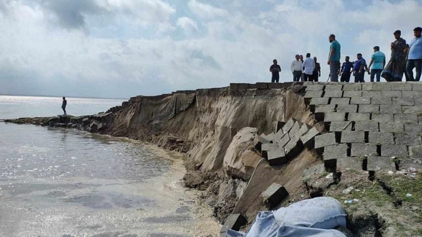
The solid spar embankment at the Meghai point of Jamuna River in Sirajganj's Kazipur upazila gave away in face of the river's strong current as the river swelled with monsoon rains in July this year. PHOTO: COLLECTED

Apart from adopting the Open approach, the second thing that Bangladesh needs to do is to better use the potential that geo bag technology has shown in mitigating river erosion. In contrast to the hard structures, the geo bag technology has many features that make it more suitable for the conditions of Bangladesh's rivers. However, the authorities have so far been more interested in using the geo bag technology to protect embankments than to protect riverbanks. For example, after some apparent success of the geo bag technology in the protection of the embankments under the Jamuna-Meghna River Erosion Mitigation Project (JMREMP), the authorities have taken up Flood and Riverbank Erosion Risk Management Investment Programme (FRERMIP) to make more use of geo bags for the protection of embankments. Some use of geo bags has been planned under the RBIP too, to protect the new embankment to be built under this project.

Unfortunately, the full potential of the geo bag technology cannot be realised if it is directed at the protection of embankments, because the latter intensify the problem of erosion themselves. Hence, protection of the riverbanks, not protection of embankments, needs to be taken up as the goal. It is only under the Open approach that the potential of geo bag technology for stabilising riverbanks can be better realised. Thus, Bangladesh should abandon the idea of building and protecting embankments and instead focus on riverbank stabilisation using the geo bag technology.

Many are now interested in narrowing the major rivers drastically and conceiving this as a one-shot affair to be carried out immediately. This is a dangerous illusion. First, it is necessary to understand the causes that have led to the widening of the rivers. Once these causes are established, efforts will have to address those causes, so that the efforts at narrowing the rivers can work with nature, rather than against it. Second, just as the widening did not happen overnight, the narrowing cannot be done right away. Instead, it can only be a long-drawn process. Third, the first step in this process has to be stabilisation of the riverbanks. Once this goal is achieved, further steps can be taken to reduce the width. The additive property of the geo bag technology can be helpful in this regard.

Thus, a combination of the Open approach and geo bag technology will be necessary to achieve the long-term goal of narrowing the rivers and reclamation of the lost land. The sooner the water authorities accept these lessons, the better it will be for the country.


Dr S Nazrul Islam is former chief of development research at the United Nations Department of Economic and Social Affairs.

Comments

Why Western approaches can't prevent river erosion in Bangladesh

This newly constructed school building in Madaripur's Shibchar upazila was able to withstand the force of the Padma's current for two weeks before it collapsed into the river, thanks to the erosion. FILE PHOTO: STAR

With each passing year, Bangladesh's land gradually crumbles and washes away due to river erosion. According to researchers, the total amount of land eroded by the Ganges, Jamuna, Padma, and Lower Meghna rivers between 1973 and 2014 was 182,000 hectares, while the accretion amounted to 80,000 hectares, signifying a net erosion of 102,000 hectares – exceeding accretion by 2.3 times. River erosion is devastating for the people who lose their homesteads and lands for cultivation. While a fire leaves some traces and allows people to rebuild in the same place, erosion represents complete annihilation that leaves no trace and no place to rebuild. It literally makes people destitute.

Over time, river erosion has also become costlier for both the affected people and the nation as a whole. With economic development, there are now more capital construction (buildings and structures), both public and private, in the rural areas. All this capital gets washed away by river erosion.

It is true that eroded banks add to the sediment that the rivers ultimately carry to the estuary and, as a result, more land is rising above the sea level. However, this gain in the estuary cannot compensate for the loss suffered inside the country. It takes decades and a lot of new investment to develop the newly risen land to make it comparable in value to the land lost inside the country. Hence, mitigation of river erosion is an important task from both humanitarian and economic viewpoints. The question is, how to achieve this goal?

To control erosion, the authorities so far have used Western methods that focus on construction of hard structures, such as groynes, spurs, concrete revetments, hardpoints, etc. Also, following the Western advice, the authorities adopted the Cordon approach to rivers and constructed embankments to cordon off floodplains from rivers. Unfortunately, neither the embankments nor the hard structures have proven to be effective in Bangladesh. In fact, they have proven to be a deadly combination instead.

For years, people in Bangladesh have been living with the devastating effects of river erosion, losing their homes and croplands. This photo was taken in Sirajganj. PHOTO: STAR

The experience of the Jamuna River provides a good example. The Cordon approach was applied to this river through the construction of the Brahmaputra Right Hand Embankment (BRHE) in the 1960s to cordon off the right-hand-side floodplains from the river. This project was financed largely by the World Bank. Also, numerous hard structures were built to prevent the right-side bank from erosion. Yet, the river eroded its right-side bank and moved westwards by more than 1.5 kilometres on average. The BRHE had to be continually retired and moved back, by more than nine times at some places. As a result, currently only 41 kilometres of the original 180-kilometre embankment remain standing. In many places, the embankment has virtually ceased to exist. The experience with other rivers has been in essence similar to that with the Jamuna River.

Figure: Erosion and accretion by major rivers of Bangladesh (1973-2014)
Figure: Annual volume of flows of the Ganges, Brahmaputra, and Rhine rivers (in cubic km) Source: Author, based on data from Dai, Aiguo and Kevin E. Trenberth (2002)

The reason why the Western approaches have not succeeded is because rivers in Bangladesh are not the same as those commonly found in Western countries. There, rivers are generally timid, with low volumes of water, very little sediment, and no pronounced seasonal fluctuations. By contrast, the major river systems in Bangladesh have high volumes of water, contain enormous amount of sediment, and are characterised by extreme seasonality. For example, the annual volume of water in the Rhine River in Europe is 75 cubic kilometres, compared to the 628 and 404 cubic kilometres of the Brahmaputra and Ganges rivers, respectively. The contrast is even more striking regarding sediment: the Rhine River carries only about three million tonnes, compared to 1,150 million tonnes carried by the major rivers in Bangladesh. Add to this the fact that about 80 percent of the flows in Bangladeshi rivers is concentrated to only four months of the year, while the water flow of the Rhine is almost evenly distributed across the seasons. Hence, it is not a surprise that in summer, major rivers in Bangladesh turn into seas, a fact that prompted a young Amartya Sen, the future Nobel laureate economist, to ask his father, "Is it really a river?" (Home in the World, Pg 20).

Investigating into the problem, Peter Rogers, professor of environmental engineering at Harvard, concluded that the "physical force of Bengal rivers is so great that no amount of engineering works can withstand it." He also observed that "the search for embankment protection from floods in the great delta is almost certain to lead to waste and disappointment." Prof Rogers also reminded the Western consultants of the necessity for "awareness of being outsiders" (Eastern Waters Study, Pg 73-74). Unfortunately, Prof Rogers proved to be a minority, if not lone, voice among the Western consultants, and his views did not accord well with the material interests of water agencies in Bangladesh as well as Western lending agencies, who are always eager to push for big-budget construction projects. Accordingly, Prof Rogers was shunned.

However, the experience shows clearly that Bangladeshi rivers require a different approach and different methods than those that worked for the rivers in the West. As I have shown in detail in my recent book, Water Development in Bangladesh – Past, Present, & Future, Bangladesh requires the Open approach to rivers so that their summer flows can spill over the floodplains and thus create less pressure on the banks. Instead of hard structures, Bangladesh requires soft structures that are malleable and can cope better with the constant pressure for course-shifting by its alluvial rivers.

Investigating into the river erosion problem, Peter Rogers, professor of environmental engineering at Harvard, concluded that the "physical force of Bengal rivers is so great that no amount of engineering works can withstand it." He also observed that "the search for embankment protection from floods in the great delta is almost certain to lead to waste and disappointment." Prof Rogers also reminded the Western consultants of the necessity for "awareness of being outsiders."

Also, instead of following the dominant Western advice and methods blindly, the water authorities in Bangladesh should have looked into the country's own heritage for solutions to the erosion problem. They could then see that, before the Western agencies came with the idea of embankments, people had always kept the floodplains open to rivers so that the monsoon flows could spill over the banks and nurture the floodplains. The spillover lessened the pressure on the riverbanks and reduced erosion. People also dug canals, called kata khal, at the pressure points so as to both relieve the pressure and let monsoon water penetrate deep into the floodplains. In addition, they used various indigenous vegetation to stabilise the riverbanks. Unfortunately, the water authorities have done just the opposite. For example, by constructing the BRHE, they closed off eight rivers that used to keep the Jamuna River connected with the floodplains on the right-side bank. Such closings have surely increased the pressure on the bank.

Hence, to mitigate the erosion problem, the first thing that Bangladesh needs to do is to shun the Cordon approach and return to the Open approach that is suitable for the country's special physical conditions, and which the people of this country have been following from time immemorial. This also requires resuscitation of the smaller rivers, rivulets, canals, etc, that used to keep the major rivers connected with the floodplains. In addition to kata khal, Bangladesh also needs to revive the old practice of Ashtomashi bandh, i.e. temporary dams lasting for eight months of the year. These dams allowed river overflows to be preserved in the floodplains and flow back to the river during the dry season to stabilise the flow across the seasons and keep the riverbed ready for extra bed scouring, rather than bank erosion, needed to hold the summer flow. Unfortunately, the water authorities seem to be heading in the opposite direction. Thus, instead of abandoning the BRHE, which has met its natural death, the authorities, together with the World Bank, have chalked up a new project called the River Bank Improvement Programme (RBIP) to rebuild the BRHE in the form of a four-lane highway, costing about $1 billion. The past experience shows that this project will only aggravate river erosion and prove to be another huge wastage of Bangladesh's resources.

The solid spar embankment at the Meghai point of Jamuna River in Sirajganj's Kazipur upazila gave away in face of the river's strong current as the river swelled with monsoon rains in July this year. PHOTO: COLLECTED

Apart from adopting the Open approach, the second thing that Bangladesh needs to do is to better use the potential that geo bag technology has shown in mitigating river erosion. In contrast to the hard structures, the geo bag technology has many features that make it more suitable for the conditions of Bangladesh's rivers. However, the authorities have so far been more interested in using the geo bag technology to protect embankments than to protect riverbanks. For example, after some apparent success of the geo bag technology in the protection of the embankments under the Jamuna-Meghna River Erosion Mitigation Project (JMREMP), the authorities have taken up Flood and Riverbank Erosion Risk Management Investment Programme (FRERMIP) to make more use of geo bags for the protection of embankments. Some use of geo bags has been planned under the RBIP too, to protect the new embankment to be built under this project.

Unfortunately, the full potential of the geo bag technology cannot be realised if it is directed at the protection of embankments, because the latter intensify the problem of erosion themselves. Hence, protection of the riverbanks, not protection of embankments, needs to be taken up as the goal. It is only under the Open approach that the potential of geo bag technology for stabilising riverbanks can be better realised. Thus, Bangladesh should abandon the idea of building and protecting embankments and instead focus on riverbank stabilisation using the geo bag technology.

Many are now interested in narrowing the major rivers drastically and conceiving this as a one-shot affair to be carried out immediately. This is a dangerous illusion. First, it is necessary to understand the causes that have led to the widening of the rivers. Once these causes are established, efforts will have to address those causes, so that the efforts at narrowing the rivers can work with nature, rather than against it. Second, just as the widening did not happen overnight, the narrowing cannot be done right away. Instead, it can only be a long-drawn process. Third, the first step in this process has to be stabilisation of the riverbanks. Once this goal is achieved, further steps can be taken to reduce the width. The additive property of the geo bag technology can be helpful in this regard.

Thus, a combination of the Open approach and geo bag technology will be necessary to achieve the long-term goal of narrowing the rivers and reclamation of the lost land. The sooner the water authorities accept these lessons, the better it will be for the country.


Dr S Nazrul Islam is former chief of development research at the United Nations Department of Economic and Social Affairs.

Comments

ঘন কুয়াশায় ঢাকা-মাওয়া এক্সপ্রেসওয়েতে একাধিক গাড়ির সংঘর্ষ, নিহত ১

মাওয়ামুখী লেনে প্রথমে একটি প্রাইভেট গাড়িকে পেছন থেকে ধাক্কা দেয় একটি কাভার্ডভ্যান। তারপরে একটি বাস প্রাইভেট গাড়িকে পেছন থেকে ধাক্কা দেয়। কাভার্ডভ্যানের পেছনে এসে ধাক্কা দেয় আরেকটি মাইক্রোবাস।...

২১ মিনিট আগে